Private Car, Public Bus or Jeep
The Manaslu Circuit Trek, combined with an exploration of the Tsum Valley, gives a unique experience for those looking to explore Nepal's mountains. This 22-day trip isn't just about seeing the world's eighth highest mountain, Manaslu (8,163 meters or 26,781 feet); it's about stepping into a world far removed from the more traveled trails of the Everest region.
Unlike those busier routes, Manaslu offers a sense of peace and a chance to connect with the local culture. The journey starts in Kathmandu, Nepal's capital, a city full of history. From there, the adventure truly begins with a drive to Machha Khola, the starting point of the trek. The path winds through green valleys, alongside rivers, and past fields carved into the hillsides.
The trek is designed to allow your body to get used to the altitude gradually. It first goes through the isolated Tsum Valley before reaching high passes like Larke La. This careful planning makes the trek safer and more enjoyable.
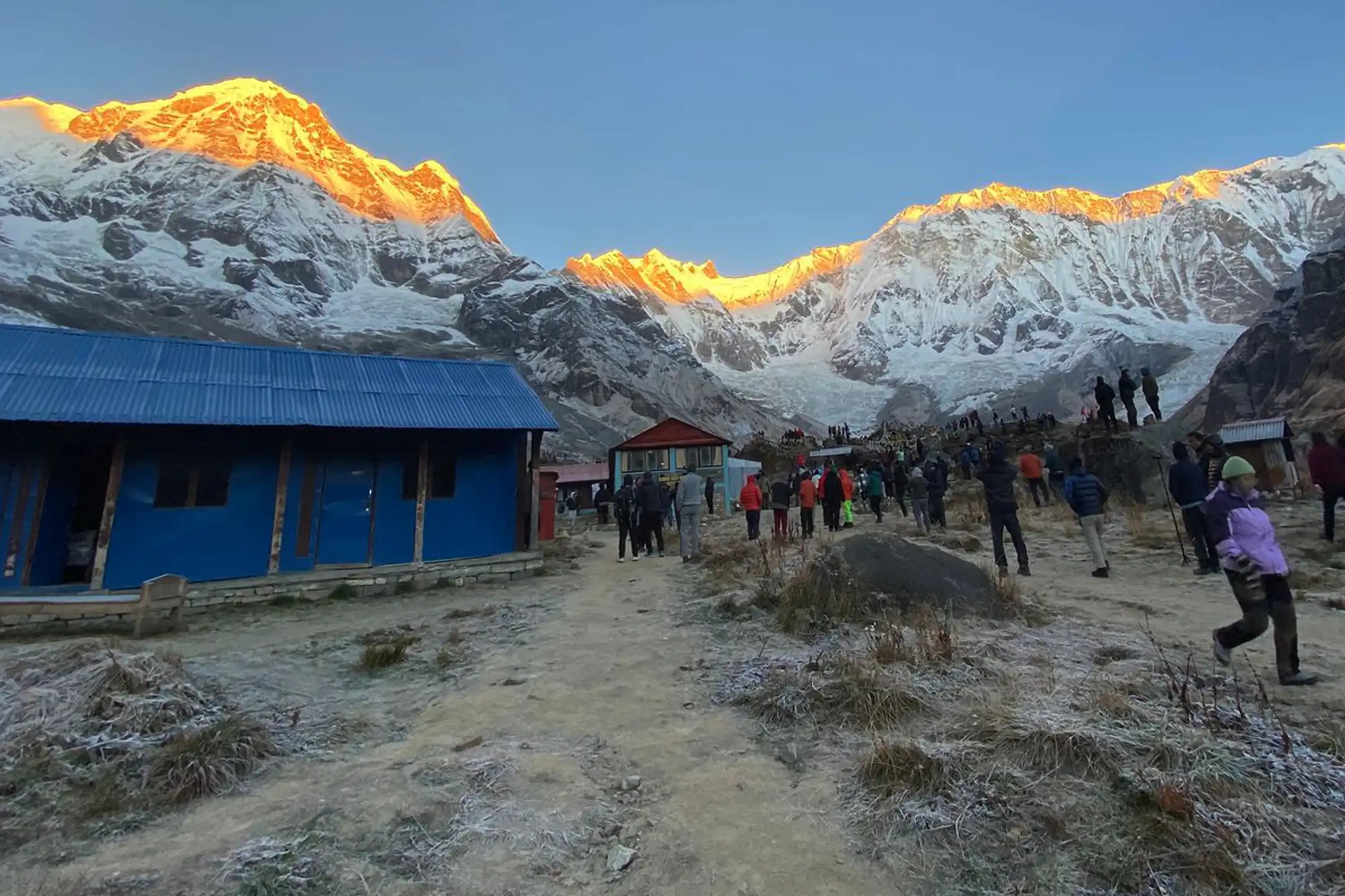
The Manaslu trek is special because of its natural beauty and cultural experiences. You'll walk through forests, alpine meadows, and see snow-covered peaks. The Tsum Valley, a key location on this trek, is filled with old monasteries, walls with prayers carved into them, and traditional Tibetan villages. These villages provide an honest look into a Himalayan Buddhist culture that has been maintained for many years.
For those who like a physical challenge, this trek is rewarding. Each day involves long walks at elevations ranging from 869 meters in Machha Khola to 5,106 meters at Larke La Pass. Trekkers will encounter tough landscapes, including river crossings, stone steps, and high- altitude passes. While suitable for hikers with some experience, it's important to be well- prepared and have good stamina to fully enjoy the trek.
The trek also offers chances to interact with the local Gurung, Tamang, and Nepalese communities. Villages like Jagat, Lokpa, Chumling, Deng, Namrung, Samagaon, and Samdo allow you to see their way of life, festivals, and religious practices. Many of the teahouses along the way are run by families, offering homemade food and a friendly atmosphere that makes the experience all the more memorable.
In conclusion, the Manaslu and Tsum Valley trek is an incredible Himalayan trip that combines challenging trekking with cultural richness and amazing views. From Mu Gompa in Tsum Valley to the Manaslu Base Camp and the famous Larke La Pass, each day brings something new, a new sight, and a closer relationship with the majestic Himalayas.
Exploring the Manaslu Circuit: A Trekker's Guide to Key Villages and Landmarks
After departing the calm scenery near Chumling, hikers will go downhill and then slowly make their way up to Deng, which sits at 1,860 meters. The village resides in a wider portion of the Budhi Gandaki River valley, complete with stepped farmlands as well as dense forested hillsides. The route to Deng consists of going across picturesque rivers, over traditional hanging bridges, and by small groups of homes with stone buildings and prayer flags marking trails. As a lively cultural spot, Deng introduces trekkers to the Tamang and Gurung people, who keep up their centuries-old customs of farming, animal care, and religious life. The village has convenient teahouses, providing warm lodging, meals, and a chance to get used to the elevation before going higher up. The hike up to Deng covers about 15 km of land, which might take around 5–6 hours, with small ups and downs, so the body can become familiar with the altitude. The surrounding area brings views of huge Himalayan mountains, especially sights of Ganesh Himal and nearby snow-covered peaks, making Deng a beautiful start to the Manaslu area.
From Deng, the route goes up steadily to Namrung, a charming village at 2,630 meters that features a backdrop of rough mountains and tall forests. The trek stretches for 15 km, usually taking 6–7 hours, with paths going across forests filled with rhododendron, stone steps, and soft ridges. Namrung stands out because of its old-fashioned design, including houses made of stone and wood, with carved windows and balconies with great detail. This area acts as a cultural center for the Tsum and Gurung residents, giving hikers helpful information on old Buddhist traditions, as well as local celebrations. As they go along the path, trekkers will come across bamboo forests, unique high-altitude plants, and flowing waterfalls, all adding to the memorable Himalayan trip. Because of where it sits, the village also lets people see Shri Kang and Manaslu peaks clearly, which becomes a great place for photos while also getting used to the high mountain air. The teahouses at Namrung are well kept and supply tasty meals and a relaxing spot before heading farther up.
As hikers move on from Namrung, the trail heads up steeply by way of alpine forests and thin ridges that take them to Shyala, residing at 3,500 meters. The distance comes to about 16 km, requiring roughly 7–8 hours, mixing hard landscape with amazing scenery. Shyala represents a changeover from the lower valleys into the alpine part of the Manaslu trek. The region gets more steep, made up of less plant life, rocky land, and snow-covered peaks that rise in the distance. Shyala represents a small region that has simpler teahouses, offering important services along with a rest stop for hikers to adapt to the high elevation. The village rests under big peaks such as Manaslu South, filling people with amazement and inspiration. Here, people can see ways of life high in the mountains, where locals take care of yaks, harvest barley, and look after old monasteries that have existed for a long time. The stunning natural scenes mixing with real culture makes Shyala a very important area before moving toward the Base Camp area.
After Shyala, hikers keep going to Samagaon, staying at the exact same height of 3,500 meters since the land moves up and down without much change. To get from Shyala to Samagaon takes about 5–6 hours on a journey that stretches approximately 11 km. Samagaon acts as an important village both for its culture and history throughout the area. The old Pungen Gompa lies here, serving as a respected monastery keeping up old Buddhist customs. From town, people can take in panoramic views of the Manaslu, Himalchuli, and Ngadi Chuli peaks, making it a great treat for the eyes. The town has stone homes, waving prayer flags, and quiet settings that create a peaceful feel, helping hikers feel how life exists way up in the Himalayas. Compared to what’s nearby, teahouses present more comfort and meals reflecting Nepali and Tibetan food traditions. Serving as a vital place to rest, Samagaon gets hikers set for tough high-altitude treks heading toward Manaslu Base Camp along with Birendra Lake.
Travelers get a chance to tackle a hike as part of getting used to the elevation heading to Manaslu Base Camp (4,800 m), or visit Birendra Lake (3,900 m) coming from Samagaon. The trek up to Manaslu Base Camp poses trials, requiring around 7–8 hours of steep ascents, going across stone-filled paths, moraines and parts filled with bits of snow. Hikers who reach the Base Camp achieve sights of Manaslu’s tall summit, rivers created by glaciers, paired with surrounding high peaks. Prayer flags in the wind and a quiet feel make the place spiritually moving. On the other hand, Birendra Lake, a bit lower at 3,900 meters, brings a more moderate hike surrounded through fields of sturdy mountain plants and tough ridges.
In both spots, those with cameras, people meditating, and individuals thinking, find pure enjoyment, perfectly capturing the main parts of the high Himalayan wild.
Hikers come down from Manaslu Base Camp or Birendra Lake and get to Samdo, resting at 3,860 meters. This village, known for its Tibetan-style homes, functions as the last area people go through before confronting Larke La Pass. Treks take 3–4 hours from Samagaon to Samdo, giving them a fairly shorter break to get used to the weather. Rich with small monasteries, walls with religious words on them, and local communities taking care of yaks, Samdo has a strong cultural presence. The nearby peaks, such as Ngadi Chuli, add stunning scenery, with local teahouses offering comfort before reaching even higher altitudes.
Trekkers leaving Samdo often visit Rui La, a well-known spot on the Manaslu Circuit. At 4,998 meters, hiking Rui La helps you get used to the altitude, since it's close to the Tibetan border. The hike is about 6–7 km, taking 4–5 hours through rocky paths, snowy areas, and high ridges. From Rui La, you can see amazing views of the Manaslu mountains, like Ngadi Chuli and Himlung Himal. The many prayer flags and mani stones along the way add to the peaceful, spiritual atmosphere. Trekkers often feel satisfied and calm here, as the beautiful Himalayas and quiet Buddhist culture come together. This hike is important for getting your body ready to walk down and cross the difficult Larke La later on.
After hiking Rui La, the path goes down a bit to Dharmashala, at 4,460 meters. Dharmashala is a small group of teahouses at the bottom of Larke La Pass. It's the final place for trekkers to rest, eat, and get used to the altitude. The walk from Samdo to Dharmashala is 6 km and takes 4–5 hours, going through rocky valleys and land formed by glaciers. The simple teahouses offer warmth and a feeling of friendship among trekkers preparing for the high pass. From Dharmashala, the Manaslu peaks and nearby ridges are very impressive, making
it a great place to look at the Himalayan landscape and calmly think about your trek. Local people have small yak farms and grow barley, showing trekkers how people survive and adapt to living in such high places.
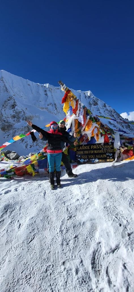
The most important part of the Manaslu trek is crossing Larke La Pass, which stands at 5,106 meters. This high pass is one of the hardest parts of the trip. Trekkers walk about 14 km from Dharmashala to Bhimtang, which often takes 8–10 hours of hard walking. The way up has steep climbs, rocky paths, and sometimes snowy areas, testing how well you can keep going and how strong you are mentally. Reaching the top gives you amazing views of Manaslu, Himlung Himal, and the Larkya range, which is a great reward for pushing through. At the top, prayer flags wave in the wind, and the quiet Himalayas provide a deep sense of success. It's a wonderful place to take photographs, think, and celebrate reaching the highest point of the trek. Walking down from the pass towards Bhimtang, trekkers will notice the change from the harsh mountain conditions to the softer highland valleys.
After crossing Larke La, the path goes down to Bhimtang, a peaceful village at 3,590 meters surrounded by mountain meadows and fields where animals graze. The walk to Bhimtang is quite long, about 14 km over 8–10 hours, but going downhill helps you recover after the difficult Larke La crossing. The village is well-known for its big, open spaces, yaks in the meadows, and mountain views, like Ngadi Chuli and Cheo Himal. The teahouses in Bhimtang offer simple but comfortable rooms and warm meals, giving trekkers a chance to rest and get ready for the walk down to the lower valley towards Dharapani. This area is also important culturally, with small stone monasteries and traditional houses showing Tibetan influences.
From Bhimtang, trekkers keep going down to Dharapani, at 1,960 meters. This part is about 16 km, taking 7–8 hours through river valleys, fields built on terraces, and mixed forests. Dharapani means going back to lower places, where the weather is nicer and the plants change back to subtropical types. People in this village still farm in the traditional ways, and the area provides a peaceful end to the high mountain part of the trek. Dharapani has good teahouses and basic things you need, offering a comfortable place to stop before the final drive back to Kathmandu. Going down lets trekkers think about their trip, appreciating the physical challenges they overcame and the rich culture they experienced along the way.
From Dharapani, trekkers get in a vehicle for the 8–9 hour drive back to Kathmandu, going back along the scenic route by the Budhi Gandaki River and terraced valleys. This drive is the last chance to enjoy the Himalayan scenery, riverside villages, and waterfalls that were part of the trek. Along the way, trekkers can stop to see rural life, local markets, and farming methods that show what life is like in the Manaslu area. The drive ends in Kathmandu, where trekkers can rest, think about their trip, and celebrate finishing one of Nepal’s most challenging and culturally interesting treks.
| Day | Route / Activity | Altitude (m) | Distance (km) | Trekking / Drive Hours |
|---|---|---|---|---|
| Day 1 | Arrival in Kathmandu, Nepal | 1,387 | – | – |
| Day 2 | Drive to Machha Khola | 869 | 160 | 9–10 hrs |
| Day 3 | Trek to Jagat | 1,340 | 16 | 6–7 hrs |
| Day 4 | Trek to Lokpa | 2,240 | 13 | 6–7 hrs |
| Day 5 | Trek to Chumling | 2,386 | 7 | 4–5 hrs |
| Day 6 | Trek to Chhokang paro | 3,031 | 8 | 5–6 hrs |
| Day 7 | Trek to Nile | 3,361 | 10 | 5–6 hrs |
| Day 8 | Acclimatization at Nile; Hike to Mu Gompa | 3,700 | 4.3 | 3–4 hrs |
| Day 9 | Trek back to Chumling | 2,470 | 17 | 6–7 hrs |
| Day 10 | Trek to Deng | 1,860 | 15 | 5–6 hrs |
| Day 11 | Trek to Namrung | 2,630 | 15 | 6–7 hrs |
| Day 12 | Trek to Shyala | 3,500 | 16 | 7–8 hrs |
| Day 13 | Trek to Samagaon (via Pungen Gompa) | 3,500 | 11 | 5–6 hrs |
| Day 14 | Acclimatization hike to Manaslu Base Camp or Birendra Lake | 4,800 / 3,900 | – | 7–8 hrs |
| Day 15 | Trek to Samdo | 3,860 | 3 | 3–4 hrs |
| Day 16 | Acclimatization hike to Rui La near Tibetan Border | 4,998 | 6–7 | 4–5 hrs |
| Day 17 | Trek to Dharmashala | 4,460 | 6 | 4–5 hrs |
| Day 18 | Trek to Bhimtang via Larke La Pass | 3,590 / 5,106 | 14 | 8–10 hrs |
| Day 19 | Trek to Dharapani | 1,960 | 16 | 7–8 hrs |
| Day 20 | Drive back to Kathmandu | – | – | 8–9 hrs |
| Day 21 | Reserve Day | – | – | – |
| Day 22 | Final Departure | – | – | – |
Embarking on the Manaslu trek, potentially combined with an exploration of the Tsum Valley, presents an amazing experience into the remote heart of the Nepalese Himalayas. To ensure a safe and rewarding adventure, it's important to consider several key aspects before starting your trek.
The Manaslu circuit reaches considerable elevations, with the Larke La Pass topping out above 5,100 meters and Manaslu Base Camp sitting at about 4,800 meters. These altitudes bring a real risk of altitude sickness. Even experienced and physically fit people can experience symptoms like headaches, nausea, dizziness, and shortness of breath as their bodies struggle to adapt to the reduced oxygen.
Therefore, a slow and steady ascent is extremely important. Give your body time to adjust as you gain altitude. Watch yourself for any signs of altitude sickness and tell your guide immediately if you experience symptoms. Incorporate sufficient rest days into your schedule and maintain good hydration. Slow your pace, especially during acclimatization hikes to places like Mu Gompa, Rui La, and Manaslu Base Camp. Your trekking guide has experience in managing altitude-related issues and can assist. A plan is also in place for emergency evacuations, should the need arise.
The Manaslu trek involves moderate to strenuous activity across varied landscapes. Be ready for everything from forested trails and rocky paths to suspension bridges and steep ascents over high passes. Ideally, you should have some prior trekking experience in Nepal or similar mountainous regions.
Cardiovascular fitness, strong legs, and overall endurance are crucial. Expect to walk for 5– 10 hours each day, often with significant elevation changes. Before your trek, focus on exercises that boost your stamina and leg strength, such as hiking, running, or stair climbing. This preparation can significantly reduce fatigue during the trek.
The best times to undertake the Manaslu and Tsum Valley trek are during the pre-monsoon season (March to May) and the post-monsoon season (September to November).
In spring, the lower valleys burst into life with rhododendrons, alpine flowers, and lush greenery, creating fantastic views. Autumn offers clear views of the Himalayan peaks, stable weather conditions, and pleasant temperatures.
Avoid trekking during the monsoon season (June to August) because the trails can become slippery and prone to landslides, with mountain views often obscured by clouds. Winter trekking is possible but can bring very cold conditions and heavy snowfall.
Manaslu and Tsum Valley are designated as restricted trekking areas. This means that you need special permits to trek there. These include the Manaslu Conservation Area Permit (MCAP) and the Tsum Valley Restricted Area Permit. You will also need a TIMS (Trekkers' Information Management System) card.
These permits are not just formalities. They are important for legal trekking and are carefully checked by local authorities. They also help to fund conservation efforts and support local communities along the trail. You can't legally enter the Tsum Valley or the higher regions of Manaslu without the necessary valid permits.
Along the Manaslu route, accommodation is primarily in local teahouses. These offer basic twin-sharing rooms, bedding, and home-cooked meals. Keep in mind that at higher altitudes, like in Samdo, Dharmashala, and near Larke La Pass, teahouse facilities are more basic. Heating may be limited, hot water might not be available, and bathrooms are often shared.
Bringing a sleeping bag, a warm insulating layer, and your own toiletries is advisable. Staying in teahouses not only provides shelter but also a chance to connect with locals and experience the unique Tibetan-influenced culture of the villages in Tsum Valley and Manaslu.
Meals during the trek often include a mix of Nepalese, Tibetan, and Western-style dishes. Expect to see rice, noodles, dal (lentil soup), vegetables, soups, and bread on offer.
Safe drinking water is essential. While water sources are available, they may not always be safe to drink directly. It's best to use water purification tablets or a water filter, or to boil your water before drinking it. Fresh fruits and snacks may be available at some stops, especially at lower elevations.
Staying hydrated is extremely important to combat the effects of altitude, fatigue, and cold weather. Carry a refillable water bottle or hydration bladder. An insulated bottle is a good idea to prevent water from freezing at higher elevations.
Packing light is important for a comfortable trek. Usually, you'll only carry a daypack with essential items, while porters transport your main luggage.
Focus on bringing layers of warm clothing, rain gear, sturdy trekking boots, gloves, hats, sunglasses, and any personal medications you need. Avoid cotton clothing, because it retains moisture and can increase the risk of cold-related problems.
Keep daily necessities like snacks, water, a camera, trekking poles, and a headlamp in your daypack for easy access. Careful packing will make your trek more comfortable and reduce strain during long days.
Be aware that mobile network coverage is limited on the Manaslu trek. Some villages, such as Jagat, Samagaon, and Dharapani, may have intermittent mobile signals or Wi-Fi access at some teahouses. At higher altitudes, in places like Dharmashala, Bhimtang, or near Larke La Pass, you probably won't have any connectivity.
Tell your family or colleagues that you probably won't be able to communicate frequently. For emergencies, rely on satellite phones or your guides. Embracing this disconnection can actually enhance your experience of the remote and peaceful Himalayan wilderness.
Every trek should be accompanied by a well-stocked first-aid kit. Guides are typically trained to handle minor injuries, altitude sickness, and other emergencies.
Having personal medical insurance that covers high-altitude trekking and emergency evacuation is something you must have. Bring your own medications for altitude sickness, headaches, stomach problems, or any other pre-existing conditions you have. High-altitude trekking carries inherent risks. Follow your guide's instructions and pace yourself.
The climate on the Manaslu trek varies dramatically as you move from subtropical lower valleys to alpine highlands and snow-covered passes. Temperatures can range from 15– 25°C in the lower regions to -10°C or lower at Larke La Pass.
Sudden weather changes are common, including snowstorms, rain, or strong winds. Be prepared with layered clothing, waterproof jackets, gloves, and hats. Weather delays can happen, so flexibility in your itinerary is important.
Manaslu and Tsum Valley are home to Tibetan-influenced Buddhist communities, and people of Gurung and Tamang ethnicities. Showing respect for local customs, religious sites, and monasteries is very important.
Avoid touching religious objects, always ask for permission before taking pictures of people, and dress modestly when visiting villages. If possible, participate in local festivals or rituals to enrich your trekking experience and show respect for the local culture.
Emergency plans are in place for the trek. These include helicopter evacuation arranged through your travel insurance, guides trained in handling high-altitude emergencies, and coordination with local authorities.
Understand that delays can occur due to weather, landslides, or road conditions. Safety is always the top priority, even if it means deviating from a fixed schedule. Extra days are usually built into the itinerary for unexpected situations, for a safe and enjoyable trek.
Upon arrival at Kathmandu, trekkers are welcomed at Tribhuvan International Airport and transferred to a tourist-standard hotel. At 1,387 meters, Kathmandu serves as the perfect introduction to Nepal, blending rich cultural heritage with modern amenities. This day is reserved for rest, acclimatization, and preparation, including gear checks and trekking briefings. Trekkers can explore the vibrant city streets, visit historic temples like Pashupatinath and Boudhanath, or enjoy the bustling markets and traditional Newari cuisine. This initial exposure sets the tone for the Himalayan journey ahead, allowing travelers to mentally and physically prepare for the adventure through Manaslu and Tsum Valley.


The trek officially begins with a long scenic drive from Kathmandu to Machha Khola, covering 160 km over 9–10 hours. The route winds through lush valleys, terraced rice fields, and rivers, offering glimpses of rural Nepali life along the way. Machha Khola, situated at 869 meters on the banks of the Budhi Gandaki River, is the trailhead for the Manaslu Circuit and Tsum Valley. Trekkers meet their porters and guides here, finalize trekking permits, and take in the serene riverside landscapes. The village itself is quaint, with small teahouses and traditional stone houses, providing a warm welcome into the remote Himalayan environment.
From Machha Khola, the trek begins along the Budhi Gandaki River, passing dense forests, suspension bridges, and traditional villages. Trekking approximately 16 km over 6–7 hours, travelers arrive at Jagat, a gateway to the Manaslu Conservation Area. Jagat is a small, charming village where trekkers register for permits and acclimatize to the increasing altitude. The landscape features terraced fields, gushing streams, and occasional waterfalls. Mani walls and prayer flags begin to dot the trails, introducing trekkers to the region’s strong Buddhist heritage. Jagat’s teahouses provide comfortable meals and a place to rest for the night while absorbing the local culture.
Leaving Jagat, the trail ascends steadily through dense forests and along river valleys to reach Lokpa at 2,240 meters. Covering 13 km in 6–7 hours, this section combines moderate climbs with breathtaking Himalayan scenery. Trekkers encounter terraced fields, traditional stone stairways, and charming rural villages along the way. Lokpa offers a glimpse into the traditional lifestyle of the local communities, with wooden houses and Buddhist shrines lining the path. The surrounding landscapes reveal panoramic views of the Manaslu range and nearby peaks, and the higher altitude prepares trekkers for the Tsum Valley region ahead.
The trail continues to Chumling, located at 2,386 meters, entering the lower regions of Tsum Valley. This shorter trek of 7 km takes approximately 4–5 hours, allowing trekkers to explore the quiet, remote villages and gently acclimatize. Chumling is culturally significant, featuring stone houses, mani walls, and small monasteries that highlight the area’s Tibetan Buddhist heritage. The trek passes through dense forests, terraced farmland, and traditional stone bridges over glacial streams. Chumling’s serene environment and warm teahouses make it an ideal spot to rest, interact with locals, and experience the authentic Himalayan lifestyle.
From Chumling, the trail ascends to Chhokangparo at 3,031 meters, a central village in Tsum Valley. Trekking 8 km over 5–6 hours, travelers witness a dramatic shift from forested landscapes to alpine terrain. Chhokangparo is a spiritual hub, with ancient monasteries, mani walls, and prayer flags adorning the village. The locals continue their traditional farming and yak-herding lifestyle, providing trekkers with cultural insight into high-altitude Himalayan communities. The village also offers spectacular views of surrounding peaks, glacial streams, and alpine meadows, making it a scenic stop for both acclimatization and photography.
Continuing from Chhokangparo, trekkers reach Nile at 3,361 meters, covering 10 km in 5–6 hours. The trail becomes more alpine, with rocky paths, small streams, and meadows dotted with wildflowers. Nile serves as an important acclimatization point before higher elevations. Here, trekkers experience open landscapes, panoramic views of distant Himalayan peaks, and a strong sense of remoteness. The village is peaceful, with rustic teahouses and a welcoming environment, allowing trekkers to rest, enjoy traditional meals, and prepare for side hikes such as Mu Gompa.
Today is an acclimatization day at Nile, with a moderate hike to Mu Gompa, a sacred monastery at 3,700 meters, 4.3 km away, taking 3–4 hours. This hike offers panoramic views of Tsum Valley, surrounding mountains, and dense forests along the trail. Mu Gompa is a center of Tibetan Buddhist practice, providing a spiritual experience with its meditation caves, murals, and chanting monks. Returning to Nile, trekkers rest and enjoy meals at the teahouses, gaining altitude experience in a controlled, scenic environment before the descent back to Chumling the next day.
After acclimatizing at Nile and visiting Mu Gompa, trekkers descend back to Chumling at 2,470 meters. Covering 17 km in 6–7 hours, this descent passes through alpine meadows, forests, and small settlements. The longer trekking day allows for reflection on the cultural and spiritual experiences in Tsum Valley. Returning to Chumling, travelers enjoy the village’s teahouses and interact with local families, observing traditional farming and monastic life. The descent also helps with recovery while preparing for the next leg of the trek toward Deng.
From Chumling, the trail descends through lush forests, terraced fields, and cascading streams to reach Deng, situated at 1,860 meters. Covering 15 km in 5–6 hours, this stage takes trekkers through the subtropical lower valleys of the Manaslu region. Deng is a larger settlement compared to Chumling and Chhokangparo, featuring wooden houses, small shops, and welcoming teahouses. The village lies along the Budhi Gandaki River, providing tranquil riverside landscapes and beautiful views of surrounding hills. Trekkers can observe local agricultural practices, including millet and barley cultivation, while interacting with villagers who preserve traditional lifestyles. This descent also allows the body to recover from higher altitudes, offering a more gentle trekking day amidst peaceful Himalayan scenery.
Leaving Deng, the trek ascends gradually to Namrung, located at 2,630 meters. The 15 km trail takes approximately 6–7 hours, winding through rhododendron forests, stone staircases, and terraced farmland. Namrung is a culturally rich village in the Manaslu region, with a small monastery and houses reflecting Tibetan Buddhist architectural styles. The area offers panoramic views of the surrounding valleys and peaks, while the trail features several suspension bridges crossing glacial rivers. Namrung’s teahouses provide warm hospitality, traditional meals, and an opportunity for trekkers to learn about the lifestyle of local Gurung and Tibetan communities. The gradual ascent also helps with acclimatization, preparing trekkers for higher altitudes ahead.
The journey from Namrung to Shyala, at 3,500 meters, is one of the longer trekking days, covering 16 km in 7–8 hours. The trail climbs through alpine forests, open meadows, and rocky ridges, offering breathtaking views of Manaslu and nearby peaks. Shyala is a remote settlement where trekkers begin to feel the isolation of high-altitude Himalayan life. The village has basic teahouse accommodations and is surrounded by terraced fields and grazing lands. Along the trail, trekkers may spot yaks, Himalayan birds, and colorful wildflowers. The serene environment combined with panoramic mountain vistas provides a rewarding trekking experience, blending physical challenge with natural beauty.
From Shyala, trekkers continue to Samagaon, passing the historic Pungen Gompa along the way. Covering 11 km in 5–6 hours, the trail offers a moderate ascent through alpine meadows and glacial streams. Pungen Gompa, perched above the trail, is a centuries-old monastery rich with murals, prayer wheels, and sacred relics, offering trekkers a deep insight into Tibetan Buddhist culture. Arriving at Samagaon at 3,500 meters, travelers are greeted by panoramic views of Manaslu’s north face and surrounding ridges. The village itself is a high- altitude settlement with basic lodges and teahouses, providing warmth, meals, and rest while immersing trekkers in the spiritual ambiance of the region.
Today is a full acclimatization day, with the option to hike to Manaslu Base Camp (4,800 m) or Birendra Lake (3,900 m). This 7–8 hour trek allows travelers to gain altitude experience while enjoying some of the most spectacular Himalayan scenery. The hike passes moraine ridges, glaciers, and alpine meadows, offering unobstructed views of Manaslu, Himlung Himal, and Ngadi Chuli. Manaslu Base Camp is a striking glacial plateau at the foot of the peak, ideal for photography and reflection, while Birendra Lake is a serene, crystal-clear glacial lake surrounded by high peaks. Returning to Samagaon in the evening, trekkers enjoy rest and meals in teahouses, reflecting on the spiritual and natural beauty of the area.
From Samagaon, trekkers make a short and gradual ascent to Samdo, located at 3,860 meters. Covering only 3 km in 3–4 hours, this day is designed to continue acclimatization and prepare for the upcoming Rui La hike. Samdo is a picturesque high-altitude village near the Tibetan border, featuring stone houses, monasteries, and yak pastures. The surroundings are dramatic, with towering peaks and glacial streams defining the landscape. The village is often dotted with prayer flags, and trekkers can witness the daily life of highland residents, including yak herding and barley cultivation. This short trek allows for rest and adjustment while still immersing travelers in the Himalayan wilderness.
From Samdo, trekkers take an acclimatization hike to Rui La, near the Tibetan border, at 4,998 meters. Covering 6–7 km in 4–5 hours, this hike is challenging but rewarding, providing breathtaking views of glaciers, high-altitude ridges, and Manaslu’s north face. Rui La offers a sense of remoteness and achievement, as trekkers traverse rocky ridges, high alpine meadows, and prayer-flag-adorned paths. The hike also helps the body adjust to extreme altitude before tackling Larke La Pass. Returning to Samdo for the evening, trekkers rest and enjoy traditional meals, preparing for the ascent toward Dharmashala.
Leaving Samdo, trekkers begin the ascent toward Dharmashala, situated at 4,460 meters. The trail spans 6 km and takes 4–5 hours, climbing through high-altitude terrain characterized by rocky paths, sparse vegetation, and dramatic views of snow-capped peaks. Dharmashala is a small settlement serving as a rest point before the challenging Larke La Pass, offering basic teahouse accommodations and warm meals. The surrounding area showcases pristine glacial rivers, prayer flags fluttering in the wind, and distant Himalayan ridges. Trekkers use this stop to acclimatize, interact with locals, and enjoy the serene environment as they prepare for one of the trek’s most challenging days.
This is the most challenging and rewarding day of the trek. From Dharmashala, trekkers ascend the Larke La Pass, the high point of the Manaslu Circuit at 5,106 meters, before descending to Bhimtang at 3,590 meters. Covering 14 km in 8–10 hours, the trek traverses rugged rocky slopes, glaciers, and high alpine meadows. Crossing the pass provides spectacular panoramic views of Manaslu, Himlung Himal, and Ngadi Chuli, with snowfields and moraines adding to the dramatic scenery. Bhimtang is a high-altitude settlement where trekkers can rest in teahouses, enjoying warm meals and observing the lifestyle of local shepherds and traders. This day is physically demanding but leaves trekkers with a profound sense of accomplishment and breathtaking memories.
After the high-altitude experience at Bhimtang, the trail descends gradually to Dharapani, located at 1,960 meters. Covering 16 km in 7–8 hours, the trek passes through alpine meadows, pine forests, rivers, and small villages. Descending from high elevations allows trekkers to recover while still enjoying spectacular views of terraced valleys and glacial rivers. Dharapani is a larger village along the trail, offering comfortable teahouses, hot meals, and a chance to reflect on the journey. The contrast between the high passes and this lush valley showcases the remarkable diversity of the Manaslu region.
From Dharapani, trekkers are transported back to Kathmandu by road, a journey of 8–9 hours through terraced fields, deep valleys, and scenic mountain landscapes. The drive retraces the Budhi Gandaki River valley, providing one last opportunity to enjoy the Himalayan scenery. Travelers can relax after the long trek, reflect on their experiences, and enjoy glimpses of rural life along the route. Arrival in Kathmandu marks the end of the Manaslu and Tsum Valley adventure, transitioning from remote high-altitude wilderness to the vibrant culture of Nepal’s capital.
A reserve day is included to accommodate unforeseen delays due to weather, road conditions, or altitude-related adjustments. This buffer day ensures that trekkers can safely complete the trek without pressure. It can also be used for local sightseeing, shopping, or exploring Kathmandu’s heritage sites before departure.
On the final day, trekkers are transferred to Tribhuvan International Airport for departure. After 22 days of trekking through the Manaslu Circuit and Tsum Valley, travelers leave with unforgettable memories of Himalayan peaks, remote villages, cultural encounters, and spiritual experiences. The journey concludes, but the sights, stories, and personal achievements remain with each trekker as a once-in-a-lifetime adventure in Nepal.
Our Manaslu Circuit with Tsum Valley Trek with Adventure A One Treks was an unforgettable adventure through remote Himalayan landscapes, ancient monasteries, and beautiful Tibetan-influenced villages. The peaceful beauty of Tsum Valley combined with the breathtaking mountain scenery of the Manaslu region made the trek truly special. Crossing Larke Pass was challenging but incredibly rewarding. Special thanks to Hari Tamang for his excellent guidance, support, and caring nature throughout the journey. Everything was perfectly organized, making the trek smooth, safe, and enjoyable from start to finish.
We had a fantastic experience on the Manaslu Circuit and Tsum Valley Trek with Adventure A One Treks. The trek offered stunning mountain views, peaceful trails, rich Buddhist culture, and authentic village life far from the crowded trekking routes. Every day brought new scenery and unforgettable experiences in the Himalayas. A big thank you to Hari Tamang for his professional guidance, kindness, and continuous support during the trek. Highly recommended for anyone looking for a unique and culturally rich trekking adventure in Nepal!
The Manaslu Trek with Tsum Valley through Adventure A One Treks was one of the most unique and culturally rich journeys I have ever experienced. The route around Manaslu Circuit offered dramatic mountain scenery, deep gorges, suspension bridges, and beautiful Himalayan landscapes throughout the trek. The extension into Tsum Valley was truly special, with ancient monasteries, traditional Tibetan-influenced villages, and a peaceful spiritual atmosphere. The entire trek was very well organized, safe, and professionally managed. I highly recommend this adventure for those looking for a remote and culturally deep Himalayan experience.
My Manaslu Trek with Tsum Valley was an unforgettable adventure filled with nature, culture, and high mountain beauty. The trail through Manaslu Circuit was challenging yet incredibly rewarding, offering stunning views of Manaslu and surrounding peaks. Exploring Tsum Valley felt like stepping into a hidden world with ancient traditions and peaceful villages untouched by modern life. The trek was well managed with great support, proper logistics, and experienced guidance throughout. I would definitely recommend Adventure A One Treks for this extraordinary Himalayan journey.
1. Trekking Clothing
2. Footwear
3. Backpack & Storage
4. Sleeping Gear
5. Trekking Accessories
6. High-Altitude Essentials
7. Optional / Personal Items
8. Trekking Clothing Tips
Yes, access to the Tsum Valley requires special permits as it is a restricted area. Trekkers must acquire a Tsum Valley Restricted Area Permit in addition to the Manaslu Conservation Area Permit (MCAP) and the Trekkers' Information Management System (TIMS) card. It is compulsory to have these permits, and you should always carry them. These permits can usually be obtained in Kathmandu via trekking businesses.
The Manaslu trek is generally considered to be of moderate to challenging difficulty. Individuals with some previous trekking experience will find it most appropriate. The daily trekking duration can vary from 4 to 10 hours, and the altitude ranges from 869 meters to 5,106 meters. Success on this trek requires a reasonable level of physical fitness, endurance, and, very importantly, proper acclimatization to the altitude. Before starting the hike, it may be beneficial to engage in cardiovascular workouts and strength training.
The most favorable periods for trekking in the Manaslu region, including the Tsum Valley, are spring (March to May) and autumn (September to November). Spring brings warmer temperatures, blooming rhododendrons, and lush, green valleys, offering a visually appealing experience. Clear skies and consistent weather are typical in the autumn, which makes viewing high-altitude landscapes especially good. It is generally not advisable to travel during the monsoon (June to August) and winter (December to February) seasons. Landslides and slick trails are two examples of problems that the monsoon season may provide. Heavy snowfall and extremely cold temperatures are common during the winter.
Altitude sickness is a potential risk on this trek, particularly at higher elevations such as the Larke La Pass and near Manaslu Base Camp. Headaches, nausea, dizziness, and fatigue are typical symptoms. Preventing altitude sickness is usually about gradual ascent, drinking enough water, and resting. Acclimatization hikes, like those to Mu Gompa and Rui La which is in Tsum Valley, can also be quite helpful. It's crucial to listen to your body and descend if your symptoms get worse.
The accommodations along the Manaslu trail are primarily in teahouses. Most teahouses provide basic twin-sharing rooms with beds, blankets, and pillows. Meals are also available at teahouses. The lodges at higher elevations, such as near Samdo, Dharmashala, and Larke La Pass, are more basic. Heating may be limited, and toilet facilities are often shared. It is recommended to bring your own sleeping bag liner for hygiene and warmth.
The food available along the trek includes a mix of Nepalese, Tibetan, and some international dishes. Dal bhat (rice, lentil soup, and vegetables) is very common and usually consists of a large portion of carbohydrates, which is really helpful for the journey. Noodles, soups, bread, omelets, and pancakes are other options. Where possible, fresh fruits and snacks can be purchased. It is a great idea to bring your own snacks and energy bars, especially for longer trekking days. Water can be bought or refilled along the way, but purifying tablets or a water filter are recommended.
The weather on the Manaslu trek is highly variable due to the range of altitudes. Temperatures in the lower valleys can range from 15–25°C, while higher up near the passes, they can drop to -10°C or below. Snow, rain, and strong winds are not rare, so it’s smart to bring both warm and waterproof clothing. Checking the forecast before you go and being prepared for sudden changes is always a good idea.
Mobile coverage is spotty along the Manaslu trail. You may find intermittent signals in villages, such as Jagat, Samagaon, and Dharapani, and some teahouses may have Wi-Fi, usually for a fee. However, in higher regions like Dharmashala and near Larke La Pass, you should expect little to no connectivity. It may be a good idea to get a local SIM card in Kathmandu for the best chance of getting a signal.
Yes, hiring a guide and porter is common and suggested. Most organized trek packages include a government-licensed trekking guide and a porter. Guides are important for safety, navigation, and giving cultural information. Porters help carry your luggage, which makes the trek easier for you. A good ratio is one porter for every two trekkers as one porter cannot carry a lot of heavy luggage, which can cause accidents.
Yes, emergency services, including helicopter evacuation, are available on the Manaslu trek. This is usually arranged by your guide and covered by your travel insurance. Guides carry first aid kits and are trained in dealing with high-altitude emergencies. It is a must to have travel insurance that covers high-altitude trekking and helicopter rescue because without any travel insurance, you might be in trouble during the trek.
Cash is important for purchases at tea houses, small shops, tips, and in case of emergencies. The local currency, Nepalese Rupees (NPR), is preferred. ATMs are scarce beyond the main villages. Credit and debit cards are generally not accepted outside of Kathmandu and Besisahar. It is recommended to have enough cash before starting the trek and to keep smaller denominations.
The Manaslu trek is physically requiring, has high altitudes, and has long trekking days. While fit older adults or children might be able to handle shorter parts of the trek, doing the full Manaslu and Tsum Valley circuits is best for adults who have experience trekking. It's very important to think about the person's health and fitness level before trying this kind of trek.
The Manaslu trek provides rich cultural experiences, especially influenced by Tibetan Buddhism. Trekkers will encounter ancient monasteries, mani walls, prayer flags, and traditional village life in places like Chhokangparo, Chumling, Samagaon, and Samdo. You may get a closer look into the local spiritual and cultural legacy by going to local festivals, seeing monasteries, and talking to people in the villages. Also, please be respectful of each place’s culture and take note of the important rules and ethics.
While beginners with a good level of physical fitness can try the Manaslu trek, some prior trekking experience is strongly advised. The trail has steep ascents and descents, suspension bridges, river crossings, and high passes, which can be hard for people who have never trekked before. Beginners might consider a shorter, less demanding trek before attempting Manaslu, or they should train for several months before the trek.
Layers are key when packing for the Manaslu trek. It is suggested to pack base layers (moisture-wicking), fleece or down jackets, waterproof outer layers, thermal underwear, gloves, hats, and sturdy trekking boots. Fabrics that dry quickly and wick away moisture are very helpful in managing sweat and cold temperatures. Do not forget sunglasses, sunscreen, and a hat to protect yourself from the sun.
| No of people | Price per person |
|---|---|
| 1 - 1 | $1,400 |
| 2 - 4 | $1,240 |
| 5 - 9 | $1,180 |
| 10 - 20 | $1,050 |
| No of people | Price per person |
|---|---|
| 1 - 1 | $1,350 |
| 2 - 4 | $1,219 |
| 5 - 9 | $1,124 |
| 10 - 20 | $1,099 |

| No of people | Price per person |
|---|---|
| 1 - 1 | $1,085 |
| 2 - 4 | $990 |
| 5 - 10 | $910 |
| 11 - 20 | $850 |