Public Bus, Private Car, and flight
There are treks. And then there's the Annapurna Circuit. What’s so special is that it offers jaw-dropping mountain views with diverse ecosystems, rich cultural encounters, spiritual depth, and the raw thrill of crossing one of the highest trekking passes on Earth.
Stretching across five districts of Nepal (Kaski, Lamjung, Manang, Mustang, and Myagdi), the Annapurna Conservation Area is one of the most biodiverse protected regions in the world.
And for this 14-day Annapurna circuit Trek, you’ll be passing the major routes that take you through the rhododendron forests as well as the terraced rice fields, followed by the wind-swept high-altitude terrain near the Tibetan Plateau.
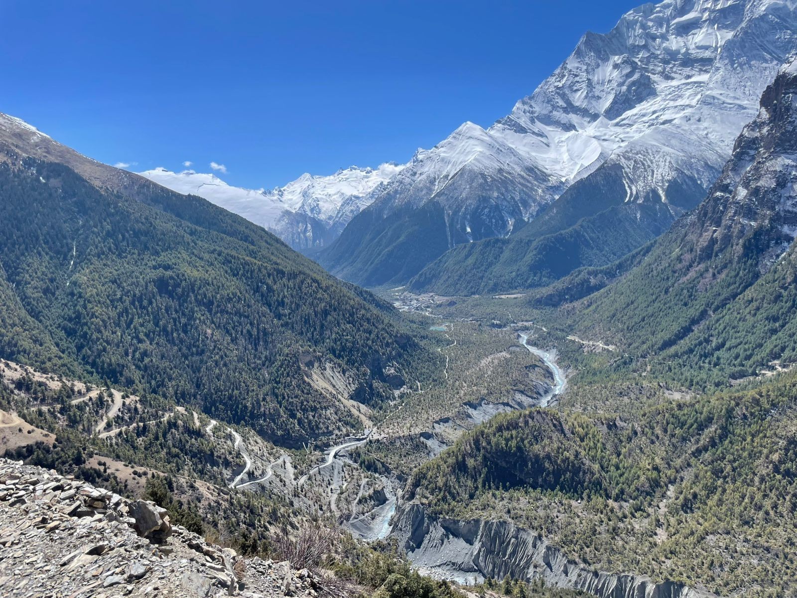
Along the way, even the mountains keep changing as you get the brilliant views of Manaslu, Lamjung Himal, Annapurna II, III, and IV, Gangapurna, Tilicho Peak, and the Dhaulagiri range. And as it’s a circuit trek, these mountains appear from different angles, different distances, at different times of day, with different lighting.
Not to forget that the Annapurna Circuit is also culturally rich, as you’ll walk through the villages of Gurung, Nyeshang, Manangi, and Bhotia communities. And you might even be lucky enough to see prayer wheels spinning beside Buddhist monasteries in Manang and Hindu pilgrims bathing in the 108 sacred water spouts of Muktinath.
You, this is an A One trek! And if you choose the journey with Adventure A One Treks, we believe your Annapurna Circuit trek would be even smoother, safer, and deeply immersive.
Our 14-day Annapurna Circuit starts from the lower altitude of Chyamje (1,460 m) rather than rushing you to the mid-section. This gives your body the proper time to acclimatize gradually.
More importantly, it gives you the real trekking experience: yes, the exact kind you came to Nepal for!
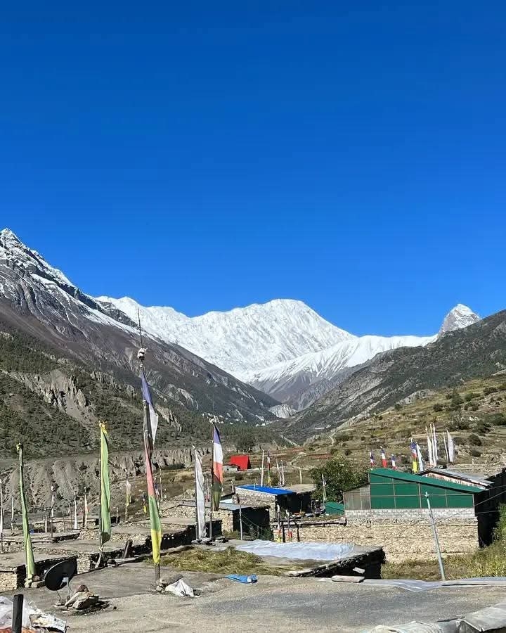
You’ll pass countless waterfalls of the Marsyangdi Valley, along with taking a peek into the ancient monasteries of Upper Pisang. Then comes the cultural hub of Manang village, where we've spent two nights for proper acclimatization and exploration.
And after crossing the major highlight of the Annapurna Circuit, Thorong La Pass, the landscape shifts entirely as you enter the Mustang district. We’ll even organize a short visit to the sacred Muktinath Temple before making our way down to Jomsom together.
So, dear guests, whether this is your first high-altitude adventure or you're returning to Nepal for more, this 14-day Annapurna Circuit has a way of surprising you at every turn. So, get ready, and let's take you through everything that makes this trek truly a one!
Before lacing up your boots, let’s understand what you're actually walking into. Well, the Annapurna Circuit is a journey through multiple landscapes, climates, and cultures that change with every passing day.
Take a quick overview of the route before we go into the details of each stop:
Chyamje > Dharapani > Chame > Pisang > Manang > Yak Kharka > Thorong High Camp > Thorong La Pass > Muktinath > Jomsom
This is the classic Annapurna Circuit trek route that has been popular for decades! Why? Because it captures the true spirit without rushing through the journey (a mistake many travellers make when visiting Nepal).
While jeeps now reach up to Manang (where road has been paved), and some itineraries skip large sections of the lower trail entirely, our team at Adventure A One believes in the classic version.
That’s why this Annapurna Circuit Trek starts from the low altitude of Chyamje (1,460 m) as mentioned earlier. This way, you get the real trekking feeling. Gradual elevation gain, proper acclimatization, and also the chance to absorb every bit of the cultural parts of the trail that others miss!
Not to forget that we also let you add Tilicho Lake to this itinerary. Yes, that's absolutely possible! This way, your Annapurna trip extends by two extra days and diverges from Manang, going to Khangsar first before reaching the iconic sacred lake. Just let us know if you’re willing ot customize, and we’ll prepare accordingly.
Let us tell you that the Annapurna Circuit is a series of unique destinations, each with its own character. Here's what to expect at each major stop:
| Source | Destination | Distance | Approx. Time |
| Chyamje | Tal | 5 km | 2 hours |
| Tal | Dharapani | 6.5 km | 3 hours |
| Dharapani | Bagarchhap | 2.5 km | 1 hour |
| Bagarchhap | Timang | 4.5 km | 2 hours |
| Timang | Chame | 8 km | 4 hours |
| Chame | Bhartang | 6 km | 3 hours |
| Bhartang | Dhikur Pokhari | 4 km | 3 hours |
| Dhikur Pokhari | Upper Pisang | 3 km | 1 hour |
| Upper Pisang | Lower Pisang | 1 km | 15 minutes |
| Lower Pisang | Green Lake | 1.5 km | 30 minutes |
| Green Lake | Humde | 7 km | 2.5 hours |
| Humde | Manang | 8 km | 2.5 hours |
| Manang | Praken Gompa (100 Caves) | 2 km | 2 hours |
| Manang | Gunsang | 4 km | 3 hours |
| Gunsang | Yak Kharka | 6 km | 3 hours |
| Yark Kharka | Churi Ledar | 2 km | 1.5 hours |
| Churi Ledar | Phedi | 5.5 km | 6 hours |
| Phedi | Thorung/Thorong High Camp | 1.5 km | 2 hours |
| Thorong High Camp | Thorong La Pass (main vantage point) | 4 km | 4 hours |
| Thorong La Pass | Muktinath | 9 km | 5 hours |
| Muktinath | Kagbeni | 12 km | 5 hours |
| Kagbeni | Jomsom | 10 km | 4 hours |
The Annapurna Circuit is, without a doubt, full of highlights! However, some stops are genuinely once-in-a-lifetime, so you wouldn’t want to miss them.
Serene glacial lakes, a hidden monastery carved into a cliff, and, of course, the mighty Thorong La, here are the extraordinary places that make this 14-day trek even more extraordinary:
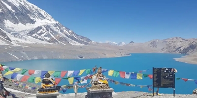
The Manang Valley can be practically called a high-altitude lake region. The reason for this is that you won't find this concentration of high-altitude lakes anywhere else. These are perhaps the best photogenic spots on the Annapurna Circuit trail:
While most itineraries send you to Ice Lake for your acclimatization hike in Manang, our Adventure A One itinerary includes something a little different. We’re taking a shorter approach, which is a hike to Praken Gompa, widely popular as the Hundred Caves (100 Caves).
It’s indeed one of the best hidden gems that many trekkers do not know. But visiting here at 3,945 m gives you a very different experience.
Located right within the rocky mountain wall above Manang, Praken Gompa is actually a Buddhist stupa. And to get there means you need to climb and get to the top.
Once you're standing at the gompa, the views are extraordinary with sweeping panoramas of Gangapurna, Tarke Kang, and Annapurna II right before you!
What’s so special about this place is that there’s a lama (Buddhist monk) here who, for a small offering, will bless you and offer protection for your crossing of Thorong La Pass. How amazing is that?
So, you see, our team at Adventure A One are not just taking you to another physical acclimatization hike, but instead a spiritual one that will bless you! Since the upcoming trek after Manang is demanding, you’d feel blessed reaching here!
Now that being said, we suggest carrying a small token of gratitude. And keep in mind: you need to approach the gompa with respect!
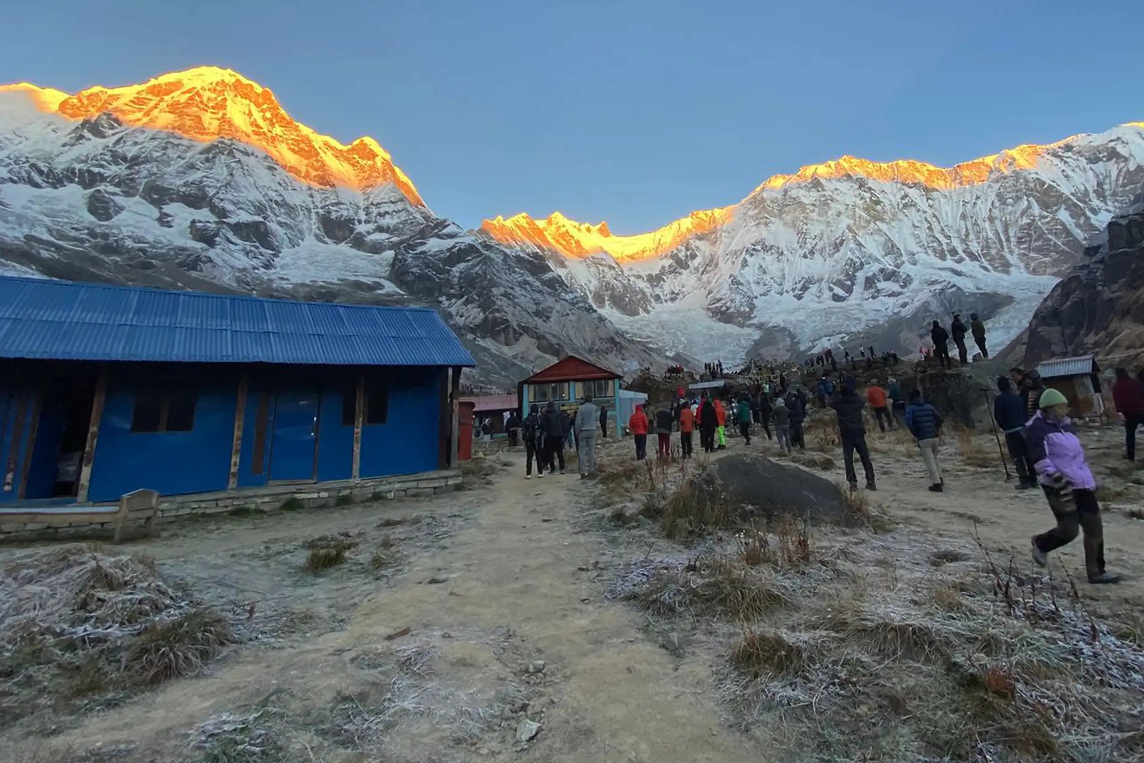
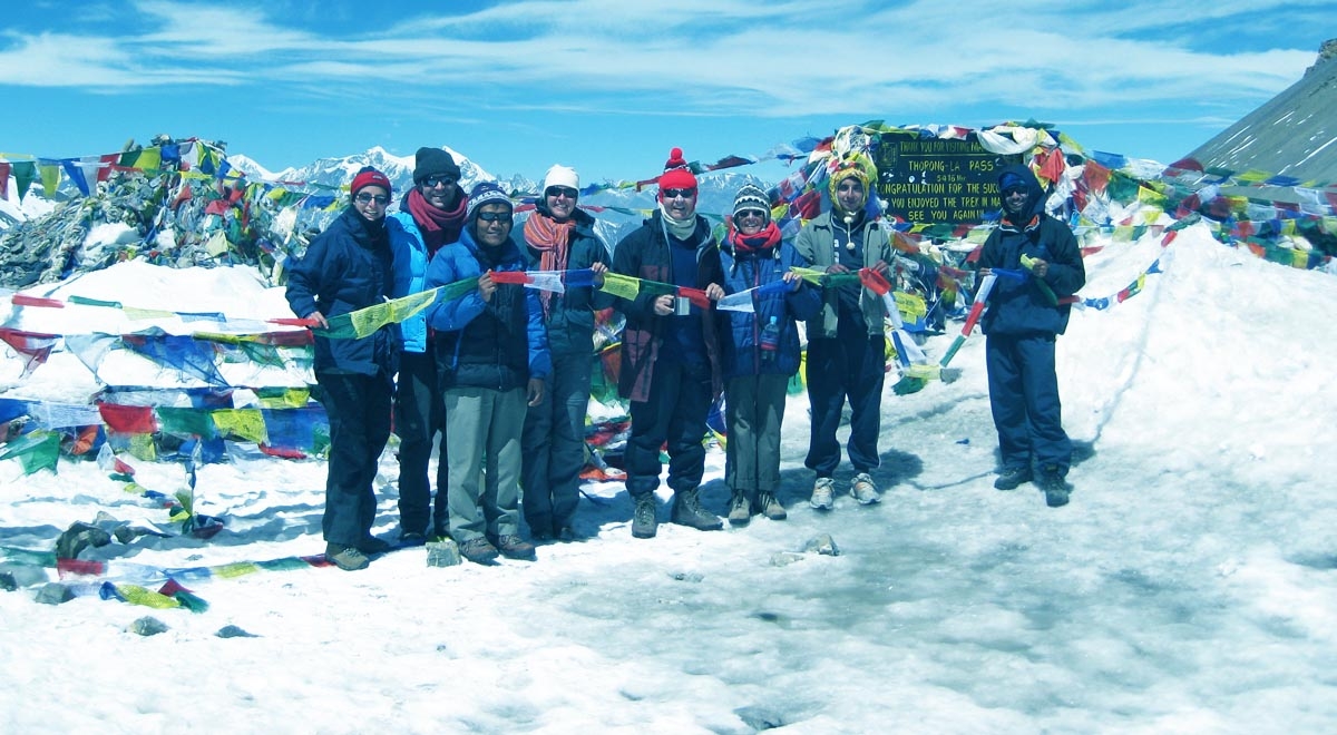
Whatever you call it, Thorong La, Thorang La, or Thorung La, this is the iconic mountain pass that holds a title that says it all: the world's highest trekking pass!
It’s vantage point is situated at an elevation of 5,416 m, and it sits right on the border between Manang and Mustang. Considering all these reasons, crossing it is without a doubt the biggest flex of the entire Annapurna Circuit journey.
But hold on! It isn't just the altitude that makes it so blissful. It's the achievement that counts.
That long climb in thin air from early morning, walking in the cold and deep silence, and only the sheer scale of the mountains around you. Even imagining makes the moment really priceless, so imagine how it feels once you’ve done it?
Well, everything you've been through over the past several days suddenly makes complete sense once you come across that iconic board of Thorong La Pass. And the views of Chulu West, Khatung Kang, the Annapurna range, and the distant Dhaulagiri range are a bonus!
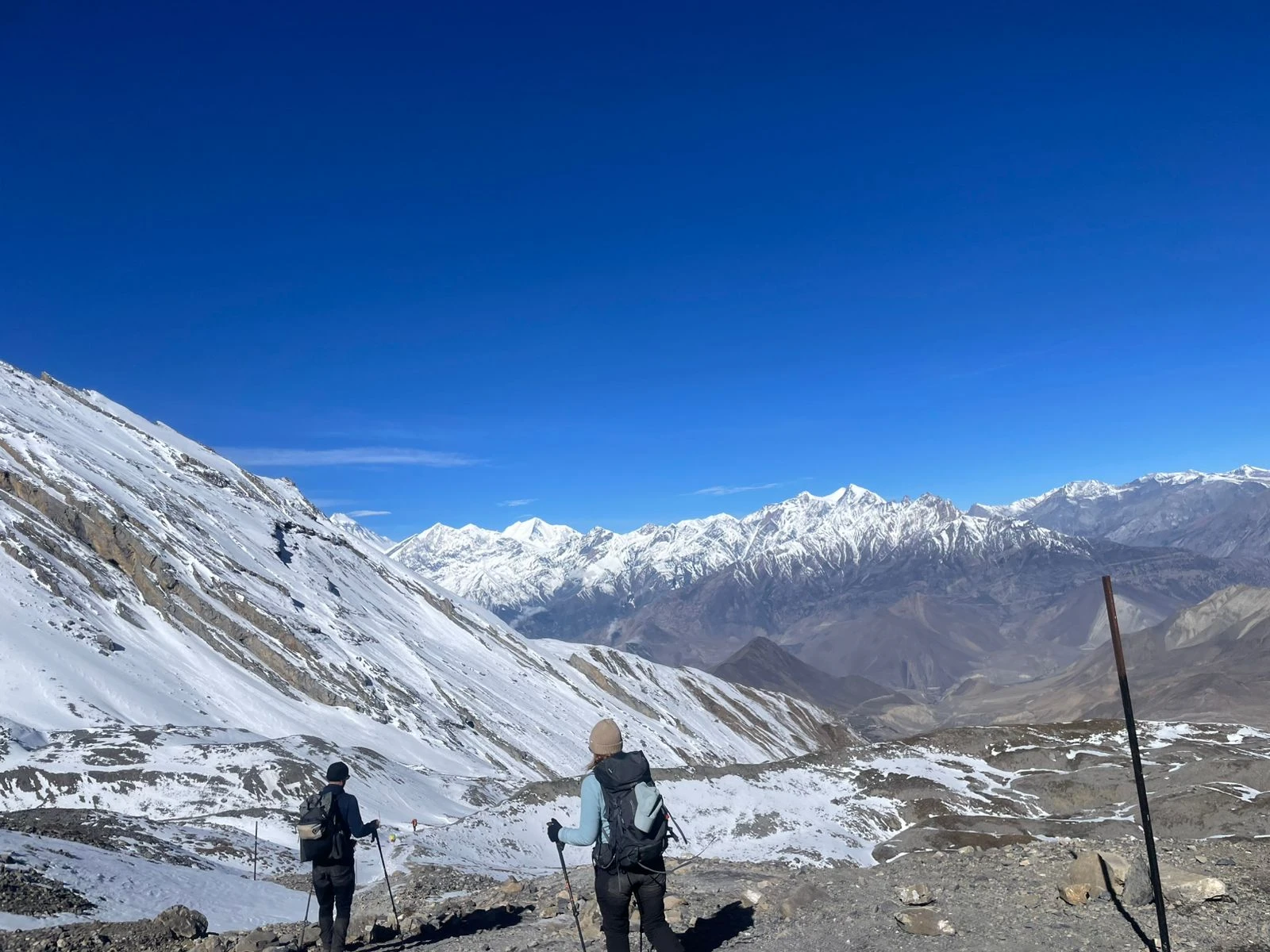
Moreover, the descent from Thorong La is equally dramatic! Get ready for the knee-hurting downhill as the landscape suddenly shifts as you drop into Mustang district.
A few hours prior, you were among the rocky alpine world of Manang, and now you’re heading to the dry, wind-carved terrain of a trans-Himalayan valley. Yup, it's like walking into an entirely different country (but you’re still in Nepal, we’re sure, already in love with this country).
But please know that slow and steady always wins here because it’s in a high-altitude region. So, don’t rush as the risk of altitude sickness is there (more on this below!).
One of the most rewarding parts of the Annapurna Circuit is the mountains (you guessed it!).
Well, they don’t just appear all of a sudden, but reveal slowly, from different angles, different distances, and different elevations, which is what we love the most in this journey. And so have our prior guests at Adventure A One Treks.
The primary ones are the Annapurna and Mansiri Himal range, which are indeed breathtaking and the major reasons many choose this adventure! Good news for mountain lovers: you get to see them from the lower sections of Chyamje to Chame itself!
The main mountains seen in the early trails are: Lamjung Himal (6,983 m), Manaslu (8,163 m), Annapurna II (7,937 m), Annapurna IV (7,525 m), Gangapurna (7,455 m), Tilicho Peak (7,134 m), and a few glimpses of Annapurna I (8,091 m) too!
But once you reach Manang and beyond, the entire Annapurna Massif becomes your backdrop!
This means you’ll be greeted with more mountains, including Annapurna III (7,555 m), Pisang Peak (6,091 m), Chulu East (6,584 m), Chulu West (6,419 m), Khatung Kang (6,484 m), and Thorong Peak (6,144 m). And from the top of Thorong La Pass, the distant Dhaulagiri Range also covers the western horizon.
Let's be honest… the Annapurna Circuit is definitely not going to be a casual walk, especially if you haven’t hiked in the mountains before. But is it as difficult as many portray? Probably not.
Well, the trail is actually a moderately challenging trek, where the main challenge is the altitude gain that comes beyond Pisang (above 3,000 m). The overall route is honestly manageable even for trekkers with limited prior experience.
However, if you do not listen to your body, you may fall seriously ill. But the main highlights have to be: the constant views, the cultural stops, and also the short, refreshing breaks that come along the way.
The one genuinely hard day is going to be when crossing Thorong La Pass. But that’s the whole point of the trek and the main highlight to cross the pass and reach the other side of the Annapurna CA. That’s why we are letting your body acclimatize for over a week.
With the right preparation and a good itinerary (like ours), most trekkers find the pass crossing demanding but absolutely achievable. This comes from our own team’s experience as well as our guests’ review.
Of course, the risk of altitude sickness is the main reason this trek is classified as moderate to challenging because you’ll have to pass such a high-altitude region. But don’t worry! Choosing a reliable agency like Adventure A OneTreks lets even beginners complete this trek and savour it for a lifetime.
You see, the difficulty level of the Annapurna circuit Trek actually depends on your experience and physical fitness.
Nepal has six distinct seasons, and each one brings a very different kind of beauty to the Annapurna region. Here's a quick overview of the main highlights (and cons too) of different times of the year in the Annapurna Circuit:
You see, all seasons have their own charm. Thankfully, at Adventure A One, we organize trips all year round so we get to cater for our guests at any time of the year they’d like.
The only time we won't consider it is when Thorong La Pass becomes impassable due to heavy snow or when road and trail conditions make the trek unsafe (during peak monsoon).
Our team is constantly monitoring the weather and trail conditions for you, so just contact us, and we’ll let you know the right time to do the Annapurna Circuit Trek.
On this 14-day Annapurna Circuit Trek, your accommodation is going to be on a mix of comfortable city hotels and authentic mountain lodges:
Speaking specifically about the Annapurna trekking route, most teahouses provide twin-sharing rooms with comfortable bedding (just basic). While hot showers are available in the lower and mid-altitude sections, they cost extra bucks (not covered by the package).
The good thing about this trekking destination is that electricity for charging is available in most locations (even up to Thorong High Camp). However, we still suggest carrying a power bank.
Also, Wi-Fi exists in some teahouses, but we won’t recommend relying on them as bad weather can cause impacts.
One important note is that the final night at Thorong High Camp can be basic. So, pack accordingly and make sure you have your sleeping bag with you!
Now, let’s talk about food on the Annapurna Circuit Trek. In the lower sections, expect Nepali dal bhat, momos, noodle soups, and chapati.
Don’t forget to try the famous Thakali Dal Bhat once you’re in the Thak Khola region (in the Mustang region). It’s honestly one of the best meals you'll have in Nepal. It’s the same as Dal Bhat Set, but more culturally rich and delicious.
Moreover, in Bhartang and Pisang, definitely opt for local apples and other apple products. And since new bakeries have opened up in Manang, be sure to try apple pie, cinnamon rolls, and proper coffee here.
Besides everything, note that this is trekking in the high-altitude Annapurna region. So, drinking more water is what you should focus on, and that too at least 3 to 4 litres per day. Always stick to boiled or purified water on the trail (avoid tap water, but if you’ve got purification tablets, using those is fine).
Other popular drinks include garlic soup and ginger tea, which are honestly your best friends at altitude!
One suggestion from our side is to avoid meat and a high-protein diet as much as possible, especially above Manang. This is because refrigeration is limited there, and most products are transported from the lower sections, so we do not know how fresh they are.
And don’t just rely on the three meals that we have included in this Annapurna Circuit Trek package for you. Be sure to carry energy bars and chocolates for the long hiking days.
To legally enter the Annapurna Conservation Area, you will require two permits (which is included in this package itself):
One of the things that truly sets the Annapurna Circuit apart from other treks in Nepal is how dramatically the culture shifts as you gain altitude. You’ll get past multiple communities as you walk through a living cultural mosaic of traditions, architecture, food, language, and spiritual life!
In the lower sections of the trail, you'll be walking through Gurung and Magar territory. The Gurung people are most abundantly found, who are warm and hospitable who are proud of their heritage.
As you climb toward Manang and Pisang, the influence of Tibetan Buddhism becomes more and more prominent. So, expect to find mani walls, chortens, prayer flags, and gompas that line the trail all along.
Here, in this region, you get to meet the Nyeshang and Manangi people, and thus get a closer glimpse of the Tibetan cultural roots that has existed for centuries. Note that spending time in Manang is a genuine cultural highlight of the entire trek (and perhaps your Nepal trip).
Don’t forget to visit the famous Braga Monastery (Braka Gompa), which is considered one of the oldest in the Annapurna region. Also, there’s Jhong Gompa near Kagbeni (after crossing the pass) that you must not skip.
Besides, in every other monastery you'll encounter on this 14-day Annapurna circuit Trek, remember to walk clockwise, remove your shoes, and be patient and respectful.
Next up is the descent into the Mustang district, where the culture shifts again. That’s the lovely part of this Annapurna Circuit Trek. And this time, you get into the world of the Thakali and Loba communities.
And we’re sure you’ve already tried Thakali Dal Bhat by now! And yes, the origin of Thakali was right here in the Mustang district’s Thak Khola region.
Jomsom and Kagbeni are also home to the Loba people, who are another unique Tibetan-origin goup whom you can meet in every alley, monastery, and household here.
Also, in case you get the chance to reach Marpha, those apple products you get to try won’t just be for taste, but to experience the culture of this region.
Besides the Buddhist traditions, this Annapurna Circuit Trek also gives you a proper glimpse into Hindo lifestyle. The visit to Muktinath Temple is a great example. It’s a sacred site where Hindu pilgrims bathe in the 108 water spouts seeking liberation.
Not just that! The temple is equally sacred to the Buddhist monks, and hence Buddhist devotees come here to honour.
Oh! And if you do the Annapurna Circuit Trek at the right time, you might be able to enjoy these festivals too: the Yartung horse-racing festival in Manang, the Tiji Festival celebrated in Mustang, or even Dashain and Tihar in the larger villages.
For the Annapurna Circuit trek, know that you'll have to walk for 7 to 8 hours daily. More importantly, you need to get past varying terrain, so your body will have to work harder than usual in thin mountain air.
Good news if you're already exercising regularly! But if you don’t, start now (at least two-three months before your Nepal trip). Here are essential tips for you to prepare the right way physically:
As important as physical fitness is, mental endurance is equally important for treks like the Annapurna Circuit. So, don't underestimate this part!
Remember that there will be days that are long, cold, and exhausting. We also won’t say there won’t be moments of homesickness and doubts, especially after you reach the high-altitude sections (beyond Yak Kharka, particularly).
In fact, many beginners don’t struggle with fitness, but with mental fatigue. So, make sure you make this decision once you’re mentally ready to go for it! Remember to train your mind just as you train your body.
But in case you feel it's difficult, there’s always the option to return. But your funds won’t be refunded, so think wisely.
In the Annapurna Circuit Trek, the risk of altitude sickness starts from Pisang (3,000 m+). From here onwards, your body has to adapt to the low oxygen levels, which is why we have been referring to ‘acclimziation’ all along this package.
Here are the most common AMS symptoms that you need to watch out:
Note that if you ignore these general signs of AMS, it can escalate to HACE (High Altitude Cerebral Edema), where symptoms rise to serious conditions like:
Now, if you again ignore signs of HACE, HAPE (High Altitude Pulmonary Edema) can develop, where symptoms include:
Note that both HACE and HAPE are life-threatening. So, please do not ignore the early signs, ever!
Here are some general ways to help you prevent AMS on the Annapurna Circuit:
To complete the Annapurna Circuit Trek, this classic 14-day itinerary is perhaps the best, and we have curated the package accordingly. But close to this part of the Annapurna Conservation, there are a lot more additional treks to go for.
Here are some popular extensions and variations our guests have loved before, so you could pick any one and we’ll help customize a dedicated package for you:
Whatever your idea of the perfect Annapurna adventure looks like, just let us know and our team at Adventure A One Treks will help you build it. All you have to do is reach out to us directly, and hand us your logistics duty while you focus on making your Annapurna Circuit Trek a one!
Other popular treks in the Annapurna region include the Mardi Himal Trek, Mohare Danda Trek, and Ghorepani Poon Hill Trek.
At Adventure A One Treks, our team doesn't believe in one-size-fits-all adventures. We surely understand that everyone has different travel goals, different fitness levels, and also different expectations.
So, our team’s main job here at A1 Treks is to understand you and what you want from the Annapurna Circuit Trek. This way, we ge to build an experience around that.
You see, whether you're a first-time trekker or a seasoned explorer, our expertise and commitment at A1 Treks are what will make your journey safe, meaningful, and unforgettable (we promise!)
Even our guides have the reputation of being the best in the country. They are government-licensed, deeply experienced, and personally passionate about the trails they lead.
They are the ones who will help you push you and take you on detours. In fact, we trust them so much that we leave the complete field duty (including selection of teahouses) to them. So, they are also local experts and no matter how many guidebooks you scour through, their expertise is what makes your journey meaningful!
And what makes our 14-day itinerary more unique is that we start from the low altitude of Chyamje (instead of Chame that most other trekking agencies choose). And this ensures you get the classic trekking experience with proper acclimatization rather than rushing to cross the pass.
Moreover, our exclusive acclimatization hike to Praken Gompa (aka 100 Caves) is yet another cultural and natural attraction that many might not consider a part of their Annapurna journey.
| Day | Destination / Activity | Altitude | Duration |
|---|---|---|---|
| Day 1 | Arrival in Nepal & Transfer to Hotel (Kathmandu) | 1,370m / 4,493ft | — |
| Day 2 | Drive to Chyamje | 1,460m / 4,790ft | 7–8 hrs drive |
| Day 3 | Trek to Dharapani | 1,920m / 6,299ft | 5–6 hrs trek |
| Day 4 | Trek to Chame | 2,700m / 8,856ft | 5–6 hrs trek |
| Day 5 | Trek to Pisang | 3,230m / 10,597ft | 5–6 hrs trek |
| Day 6 | Trek to Manang Village | 3,450m / 11,318ft | 5–6 hrs trek |
| Day 7 | Acclimatization Day at Manang (Hike to Hundred Caves / Viewpoints) | 3,450m / 11,318ft | 3–4 hrs hike |
| Day 8 | Trek to Yak Kharka | 4,200m / 13,776ft | 4–5 hrs trek |
| Day 9 | Trek to Thorong High Camp | 4,880m / 16,006ft | 4–5 hrs trek |
| Day 10 | Cross Thorong La (5,416m / 17,769ft) & Trek to Muktinath | 3,800m / 12,467ft (Muktinath) | 7–8 hrs trek |
| Day 11 | Trek to Jomsom | 2,715m / 8,905ft | 4–5 hrs trek |
| Day 12 | Fly to Pokhara & Explore Lakeside | 860m / 2,821ft | 20–25 min flight |
| Day 13 | Drive or Flight Back to Kathmandu | 1,370m / 4,493ft | 6–7 hrs drive / 25 min flight |
| Day 14 | Final Departure | — | — |
Adventure A One Treks warmly welcomes you to Nepal!
The moment you step out of the arrival hall at Tribhuvan International Airport, keep an eye out for our team member holding an Adventure A One sign. That's your person who’ll escort you in a private vehicle (car/jeep/van, depends on your group size) directly to your hotel in Thamel, Kathmandu.
Once you're settled in, we'll visit you for a get-together and briefing session. You'll meet your guide, get a clear picture of what the next 14 days look like, and have the chance to ask any questions.


Today is going to be a long drive, but a beautiful one, of course. Chyamje is approximately 205 km away from Kathmandu, and the journey can take around 8 to 10 hours (depending on road conditions, which aren't always the smoothest).
Passing through the districts of Dhading, Chitwan, and Tanahun, you'll enter the Lamjung district. Starting off was the route alongside the Trishuli River, which eventually connects to the Marsyangdi.
After crossing the important towns of Dumre and Besisahar, you’ll reach Chyamje (in Lamjung) for the night. The ride itself is a major highlight before the Annapurna Circuit begins, considering the transition from the busy capital to the quiet.
And so it begins! The first day of trekking on the Annapurna Circuit is going to be a beautiful one. You’ll start from Chyamje, where you’ll feel the energy of the trail immediately.
As you walk along the sound of the Marsyangdi River beside you, waterfalls appear from the canyon walls above. That’s a beautiful way to introduce you to Nepal and its famous hiking trails.
Then, passing through Sattale, you'll continue via the Malin and Augusto waterfalls before reaching the serene Tal Village. This is one of the most striking early scenes on the circuit as discussed in the overview section above.
As you march forward, more waterfalls await before you cross Khorte and Karte and finally arrive at Dharapani for the night. That was a beautiful 5 to 6 hours hike completed covering 12 km distance.
Here, our guide will help you show your permits at the ACAP check post before heading to the local lodge. If you've got the energy, do explore the nearby gompas before dinner!
Tighten your boots and follow the guide’s instructions for when to start. It’s usually early morning, considering you need to walk 16 km in 5 to 6 hours.
If this is the spring season of the Annapurna Circuit Trek, those rhododendron forests blooming with flowers will keep you mesmerized throughout. And the same sound of the Marsyangdi River shall flow right beside you!
Passing through Thoche, Odar, Bagarchhap, Danagyu, and Timang, you’ll stop for lunch around the Kurung area. Then, post-lunch, the trail continues to Chame, passing through the small settlements of Thanchok and Koto.
You again need to show your permits at the Annapurna CA checkpost along the way. And after reaching the headquarters of Manang, you can even dive into a nearby hot spring if time allows.
And the mountain views? They are spectacular from here (with starry nights). And since it’s tucked right next to the Marsyangdi River, its sound is going to give you a peaceful sleep!
Have your breakfast early and start this manageable day that only comes with a few downhill stretches followed by some uphill sections. You'll walk past the settlements of Thaleku and reach Bhartang.
This is one of the best places along the Annapurna Circuit trail to try local apples, as there are countless apple farms here. After lunch, your trail now continues through Dhikur Pokhari, where a serene pond with mountain views awaits you for a perfect photo stop!
From here, you and your guide will head to Upper Pisang for the stay (an option for Lower Pisang exists too). Today’s trek concludes after 5 to 6 hours covering 15 km.
Once you check in, don't stay inside the lodge. Come out and explore the ancient monasteries, stupas, and prayer wheels that make Upper Pisang one of the most atmospheric and culturally-rich settlements on the entire circuit.
Wake up to a morning of magical mountain views (Annapurna II, IV, Gangapurna, and Tilicho Peak) in Upper Pisang. After breakfast with those views, we move on with the trail that passes through Lower Pisang and on to Humde.
On the way, you’ll even stop briefly at Green Lake for pictures. And post-lunch in Humde and learning about what happened to the airport, the journey continues through Mungii and Braka (don't miss Braka Monastery here) before reaching Manang Village.
Once you're checked in, have a cup of tea and begin exploring. Do keep in mind that you’re almost at 3,500 m (and some AMS issues can happen), which is why there’s two-day included here for proper acclimatization.
If you’re here on time (just 3 to 4 hours covering 15 km), you should have ample time to visit the local museum, bakeries, and even connect with the Manangi people. In the evening, return to your lodge and keep drinking hot fluids and don’t forget to have a hearty dinner (Dal Bhat is the best choice!).
For today, we have included a hike to Praken Gompa and exploration around Manang that takes about 3 to 4 hours overall. Since it’s short, you can manage your time accordingly after confirming with your guide.
To reach Praken Gumba or the Hundred Caves, it takes a solid climb. But once you’re here, the panoramic views of Gangapurna, Tarke Kang, and Annapurna II make the effort completely worthwhile.
And like we mentioned earlier, be sure to meet the Lama to get blessings for the upcoming Thorong La crossing.
After returning to Manang, you’ll have ample time left to hike up to Gangapurna Lake for sunset views and browse the local shops. It’s your day to relax, so be sure to take proper rest too!
Finally, on the eighth day of the 14-day Annapurna Circuit Trek, the serious high-altitude climb begins. Thankfully, the previous day's acclimatization hike will help your body adjust, but be mindful from here as the risk of altitude sickness increases.
So, take it slow, and follow your guide’s instructions. You’ll walk beside the Jharsang Khola, passing Gunsang before arriving at the small but beautiful settlement of Yak Kharka.
There are fewer lodges compared to what you saw in Manang and lower area. But the vibe is all local, and this is the feeling that stays with you the most. And as the name suggests, high-altitude yaks shall be grazing freely in the background, so keep your cameras on.
Today is yet another strenuous climbing day. So, you need to be mentally prepared for this one. After a solid uphill push, you'll pass Churi Ledar (4,200 m) before reaching Thorong Phedi (4,450 m).
Be sure to drink plenty of water (if possible, 4-5 litres), learn the breathing technique with your guide and apply it properly, and keep your guide informed of how you're feeling (don’t push if you’re showing extreme signs of AMS).
From Phedi, if everyone in the group is feeling well, our recommendation is to push forward to Thorong High Camp (4,880 m) for a more secluded stay. Also, the views from High Camp are superior, and you won’t even miss the sunrise the next morning.
Today, you can even explore the vantage points nearby that cross 5,000 m. They are a perfect opportunity for short acclimatization walks before tomorrow's big day (and let’s be honest: these hikes let you sleep well and early).
Now comes the biggest day of the trek. You have to wake up early (at around 3 or 4 AM), and on the way, you’ll even get to witness the beautiful golden mountain panorama. Pack lunch (from the teahouse, you need to inform your guide the day before), so the final ascent becomes easier and you get energy too.
It's approximately 4 km to the top from High Camp. Not that difficult unless because of heavy snow (which is why picking the right time is also crucial). By noon, you should have stood at Thorong La Pass (5,416 m) and even moved past there to start the long downhill stretch to Muktinath.
The descent into Muktinath covers nearly 9.5 km and passes through a completely different landscape. To reach the dry, wind-carved terrain of Mustang district, it will be about a total of 7 to 8 hours trek covering 15 km overall from High Camp.
Upon arriving in Muktinath, you’ll head directly to your lodge for a well-deserved rest (it’s done!). But in the evening, you can explore the sacred temple complex and get some rare spiritual glimpses from both Hindus and Buddhists.
If you missed the visit to Muktinath Temple the day before, an early morning visit is highly recommended here. This is because in the mornings, the temple is filled with pilgrims taking blessings and bathing in the 108 water sprouts. Meanwhile, you can even pay a visit the Jwala Mai Temple to witness the eternal flame.
Come back to your lodge and have breakfast and get ready for the hike down toward Jomsom. While even going via vehicles is an option, remember we’re going for the classic trek, so we’re going to trek!
You’ll pass through the Loba and Thakali villages of Ranipauwa, Purang, Jhong, and Putak. This gives you the beautiful glimpses of the distant Dhaulagiri range, while you get to walk beside the Jhong Khola.
There’s Jhong Gompa on the way, be sure to make a pit stop there. And after 4 to 5 hours hikes to reach Jomsom, you can now explore the lively market, visit restaurants, or visit the famous Jomsom Airport from which you'll fly out tomorrow.
In case you’re interested for a drive to Pokhara, please be sure to inform us prior. If you do so, we’ll include a short detour to Marpha as promised earlier. The apple pies, apple brandy, and charming alleys of Marpha are definitely worth every extra step!
Wake up at your pace, but be sure of your flight timing. It’s going to be a short flight from Jomsom to Pokhara.
And the highlight? Well, it’s the stunning aerial views of the Annapurna, Dhaulagiri, and surrounding ranges! So, here’s a tip: be sure to pick a window seat.
Once in Pokhara, our representative will help you check into your hotel in Lakeside, where you get to enjoy the rest of the day. You may even opt for any of these activities: kayaking or row boating. It’s your day to relax!
And in case you’re interested in the adventure activities, please be sure to confirm this to your guide. We’ll definitely help you get the best part of Pokhara (with options like paragliding, zip-lining, or even a bungee jump). It will cost you a little extra, though!
Today, you’ll return to Kathmandu by either a scenic 30-minute flight or a road journey (your call!). The route is going to be via the Prithvi Highway, and the same one you cross Dumre.
After arriving back in Kathmandu, you can explore the Thamel area (which you possibly missed on the first day), go shopping in the Ason-Indrachowk area, or simply rest at your hotel.
In the evening, we'll arrange a special farewell dinner with cultural dance performances for you! This way, we get to meet again and hear your experiences of the Annapurna Circuit Trek.
Time to say goodbye, but before that, you’ll have your final breakfast in Nepal (provided by the hotel itself). Then, based on your flight time, our representative will escort you to the airport.
This is typically three to four hours before departure, but you have to know that Adventure A One's door is always open for your next treks and tours in the country.
The Itinerary can be customized to your needs, and the primary piece of gear for day hiking is about 15/20 liters. You can keep your personal belongings in this bag.
Our Annapurna Circuit Trek with Adventure A One Treks was an incredible journey through beautiful landscapes, traditional villages, and stunning mountain scenery. Crossing Thorong La Pass was challenging but truly unforgettable. Everything was well organized, from accommodation to transportation, making the trek smooth and enjoyable. Special thanks to our guide, Dorje Sherpa, for his kindness, experience, and constant support throughout the journey. Highly recommended for anyone wanting to explore the beauty of the Annapurna region!
The Annapurna Circuit Trek with Adventure A One Treks was one of the most rewarding trekking experiences we’ve had. The changing landscapes, peaceful mountain villages, and incredible Himalayan views made every day special. The itinerary was well planned, allowing enough time to enjoy the trek comfortably and acclimatize properly. A big thank you to our guide, Dorje Sherpa, for his professionalism, local knowledge, and friendly attitude throughout the trip. We truly enjoyed every moment and would highly recommend this trek to anyone visiting Nepal.
The Annapurna Circuit Trek with Adventure A One Treks was an unforgettable adventure through some of the most diverse and beautiful landscapes in Nepal. From green valleys and traditional mountain villages to high alpine scenery and dramatic mountain passes, every day of the trek was filled with breathtaking views and unique experiences. Crossing Thorong La Pass was the highlight of the journey and a truly rewarding achievement. The panoramic mountain scenery, including Annapurna, Dhaulagiri, and Manaslu, was absolutely stunning. Everything was perfectly organized, and the team was professional, supportive, and always attentive to our comfort and safety. I highly recommend this trek to anyone looking for an incredible Himalayan adventure.
My Annapurna Circuit Trek with Adventure A One Treks exceeded all expectations. The trek offered an amazing mix of natural beauty, local culture, and adventure. Walking through peaceful villages, beautiful forests, and high mountain landscapes made the journey truly special and unforgettable. Reaching Thorong La Pass was one of the most exciting and memorable moments of the trek. The entire trip was managed smoothly, with excellent accommodation, meals, and trekking arrangements throughout the journey. The staff was friendly, experienced, and always ready to help. I would definitely recommend Adventure A One Treks to anyone planning a trekking adventure in Nepal.
The Annapurna Circuit Trek with Adventure A One Treks was an unforgettable journey through diverse Himalayan landscapes. From lush green valleys and traditional villages to high mountain deserts, every day offered something new. Crossing Thorong La Pass was the most challenging and rewarding moment, with incredible panoramic views of the Annapurna range. The trek was well organized and professionally guided.
I had a fantastic experience on the Annapurna Circuit Trek with Adventure A One Treks . The route combined rich culture, beautiful nature, and dramatic altitude changes, making it one of the most varied treks in Nepal. The mountain views were stunning throughout the journey, and the entire trip was smoothly managed. Highly recommended for anyone seeking a complete Himalayan trekking experience.
It is not so difficult, as one imagines as any other normal moderate-grade walks around the Himalayas. The only tough is gaining altitude from Pisang village onwards from above 3,000 m onwards. But taking time and enjoying the views and having short refreshing stops makes the trek much easier.
The only hard day of walking is going over Thorang-La Pass. By then all trekkers will be well acclimatized with the altitude to encounter the difficult part of the adventure. Slow and steady with few stops in between the walks makes the trek more enjoyable.
Depending upon the seriousness and nature of sickness, for minor suffering and illness, one can rest for a few days. Then can carry on trekking, but must have someone close to accompany the victim. For major illnesses and severe wounds, the patient needs immediate evacuation by the fastest means of transportation. Like using helicopter services, where all trekkers should be fully insured and claimed through concerned insurance companies.
The company Adventure a1trek will provide an expert guide with Government license Holder and very helpful porters to take care of your needs and requirement. The guide can answer all your queries as well providing information about the area of trekking, local culture, and much more.
Eight to fifteen kilometers is what you cover each day, though it shifts with how steep the land gets, how much climbing there is, also where breaks happen. Shorter stretches show up at high elevations because bodies need time to adjust.
Starting out without past hikes on record? That works too - if basic stamina is solid, planning covers essentials, plus listening to trail leaders comes naturally. Success shows up when readiness meets guidance.
Down in the lower villages - Chyamje, Besisahar, Jomsom - you can still find network signal. Yet once you climb past Manang, service fades out. Higher up, connection turns spotty or vanishes altogether.
Out here in bigger villages - Manang, Jomsom - you’ll find basic health outposts standing ready. Yet when trouble strikes, say altitude sickness or something worse, a helicopter lift becomes the only way forward.
Folks speak Nepali across the region, while tongues like Gurung, Thakali, or Sherpa pop up in their own corners. In lodges and through guides, you’ll catch English without much trouble.
Tea houses usually serve food that suits vegetarians. Alongside local dishes, you might find basic Western-style plates on the menu. Checking ahead with your guide helps avoid surprises.
When visiting villages or monasteroes, wear clothes that cover more skin because it shows respect. If you want to take someone's photo, speak to them first - it matters to many. Before stepping into holy places, leave your shoes outside as a sign of care.
A trek through the Annapurna Circuit skips the tight access limits seen in places like Upper Mustang - yet guides with proper licenses still make things safer, easier to follow. Though not required by law, their presence smooths out rough patches on the trail.
True, you can charge devices at many teahouses - for a little money - but power might flicker or vanish without warning. A portable battery pack makes sense here instead.
Up high, guides keep the climb slow so bodies adjust without trouble. Each day’s progress gets checked carefully; rest periods slip in when needed. Safety shapes every decision along the way.
Few trekkers spot snow leopards, though they do wander high and far where terrain gets rough. Monkeys move through trees above rocky slopes while birds call from unseen branches. Pheasants dart between shrubs near silent ridges where few pass. The Himalayan Thar stands still on cliffs, blending into stone like weathered rock.
Adding a stop at Ghorepani, Poon Hill, or another close village? Possible - though it might shift the schedule forward by one or two days. Sometimes plans stretch when paths branch off. Each extra place nudges time like ripples in water. Flexibility becomes key once trails split into quieter zones.
Most trekkers skip packing heavy items - Kathmandu and Pokhara offer rentals. Boots? Available. Need a warm bag for cold nights? Easy to find. Down jackets, too, sit ready on shelves. Walking poles get handed out like trail maps. Gear shops pop up near every hostel. Renting saves space in your luggage. Some outfits even deliver to guesthouses. Prices stay low, especially for longer trips. Just check condition before signing out. Many stick to rental kit rather than haul their own.
| No of people | Price per person |
|---|---|
| 1 - 1 | $1,400 |
| 2 - 4 | $1,240 |
| 5 - 9 | $1,180 |
| 10 - 20 | $1,050 |