The August 26, 2026 Bhote Koshi flood changed access to Gosaikunda and Langtang. Current route status, the official alternate routes, and what trekkers should do now.
Key Takeaways - A flash flood struck the Bhote Koshi river in Rasuwa on the morning of August 26, 2026, after a glacier-and-rock collapse near the Nepal-Tibet border. As of August 30, Nepal reported 734 dead and 2,498 missing, with more than 3,700 rescued (Nepal authorities; The Guardian). - The flood damaged the Kathmandu-to-Rasuwagadhi corridor that serves the Langtang and Gosaikunda region: whole sections of the 42 km Betrawati-Rasuwagadhi road, at least 22 bridges, hydropower plants and the border customs office (ReliefWeb). - Rasuwa district is an active disaster zone and should not be visited. The standard Dhunche approach to Gosaikunda is closed; the Ministry of Culture, Tourism and Civil Aviation has directed trekkers and pilgrims returning from Gosaikunda to use the alternate Dupcheshwor route until further notice. - Langtang and other treks outside Rasuwa are unaffected. If your destination does not use the Rasuwa corridor, your plans carry on as normal; always confirm current trail and road status with a licensed operator before departure.
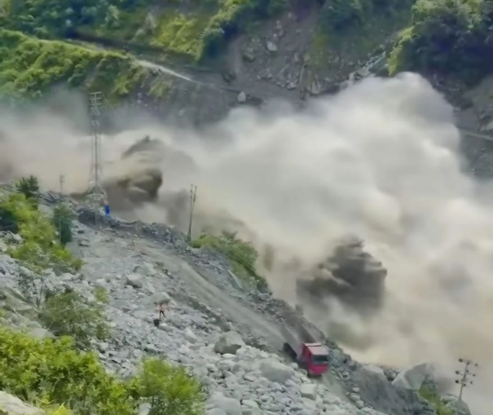
On Wednesday, August 26, 2026, around 9:00 AM Nepal Standard Time, a massive wall of water and debris surged down the Bhote Koshi river in Rasuwa district, entering Nepal from the Tibet Autonomous Region of China. The surge moved through the Trishuli river system past Nuwakot, Dhading, Gorkha, Tanahu and into the Narayani system as far as Chitwan and Nawalparasi East.
What triggered it: Scientists now point to a glacier-and-rock collapse rather than rainfall. Satellite imagery from Planet Labs showed a section roughly 600 metres wide collapsing from an altitude of about 5,200 metres and falling around 1,200 metres into the Lhende Khola valley on the border. The collapse blocked the river, forming a temporary natural dam that gave way, releasing a sudden surge downstream.
"The avalanche originated on Nepali territory, but after it came down it crossed the Nepal-China border, causing extensive damage on both sides." - Binod Parajuli, senior hydrologist, Nepal's Department of Hydrology and Meteorology
Scale of the disaster: The confirmed toll keeps changing as search teams reach cut-off areas. By Sunday August 30, Nepal's authorities counted 734 dead and 2,498 missing, with the combined Nepal-and-Tibet figure above 750 dead and more than 3,000 missing; more than 3,700 people have been rescued (The Guardian). The loss is devastating for the communities of Rasuwa and the districts downstream, and our first concern is with the families and rescue workers on the ground right now.
The flood's damage is concentrated on the road corridor and border settlements, not on the walking trails themselves. That distinction matters for which trips are affected and which are not.
| Route | Status | Why |
| Langtang Valley (Syabrubesi access) | Closed for now | The gateway town Syabrubesi and the approach road suffered major damage; the trail itself is not believed to be in the flood zone |
| Gosaikunda (Dhunche access) | Closed, alternate route in effect | Dhunche sits above the river, but the highway to it is damaged; the ministry directs trekkers to the Dupcheshwor route |
| Langtang / Gosaikunda via Helambu (Sundarijal south approach) | Most robust option | Uses a different road out of Kathmandu entirely, avoiding Rasuwa district |
| Everest, Annapurna, Manaslu, and all other regions | Unaffected | The flood hit one river corridor in one district; these regions are not in its path |
Rasuwa district itself is an active disaster zone and should not be visited until authorities confirm it is safe.
Gosaikunda, the sacred lake set at roughly 4,380 metres, draws thousands of trekkers and Hindu pilgrims, especially around the Janai Purnima festival. It is the centrepiece of our Langtang Valley and Gosaikunda Trek itinerary, which is exactly why we are tracking this route so closely. The Ministry of Culture, Tourism and Civil Aviation has issued an urgent advisory because of active landslide risk on the corridor.
Do not use the standard Dhunche line. The ministry has asked trekkers and pilgrims returning from Gosaikunda to avoid the regular Dhunche descent until further notice (NepalNews).
Approved alternate return route (Hamro Patro):
Gosaikunda (4,380 m) → Suryakunda Pass (4,675 m) → Phedi → Talu → Sisipu → Dupcheshwor → Kathmandu
In practice, trekkers now have three access pictures to weigh:
In practice, trekkers now have three access pictures to weigh:
A second, more robust approach from the south: the Sundarijal-Helambu line uses a different road out of Kathmandu and avoids Rasuwa district entirely. For anyone determined to trek in the Langtang-Gosaikunda region this autumn, this is currently the most stable option.
Important: These alternate routes are genuine high-altitude trekking terrain, not a convenient road detour. Suryakunda reaches around 4,600-4,675 metres, so altitude preparation still applies. Trail, bridge, weather and teahouse conditions must be verified locally before every section is committed.
For trekkers planning a Gosaikunda or Langtang-region trip, the practical picture is clear, but local and verified.
1. Do not travel to Rasuwa right now
The corridor is an active disaster zone. Rescue, recovery and infrastructure assessment are ongoing, conditions are changing fast, and the priority must remain supporting affected communities. Respect official closures even if a guidebook or old map says a trail is open.
2. A December or autumn rebooking is reasonable to consider, but confirm, don't assume
The Langtang Valley itself may open for October if the highway is cleared and Syabrubesi recovers. That is not guaranteed. For the Langtang region specifically, ask your operator what the alternate access looks like before you need it, and keep your plans flexible nearer to departure.
3. Other regions remain completely open
The vast majority of Nepal's trekking is unaffected. The Everest, Annapurna and Manaslu regions were not in the flood's path, and flights into Lukla, Jomsom and other airstrips continue. If your destination does not need the Rasuwa corridor, your plans carry on normally. For the wider picture of trekking this part of the Himalaya once conditions settle, our Langtang region trekking compares the valley routes, Gosaikunda and the Ganja La.
Here is a priority-ordered checklist for anyone with Gosaikunda, Langtang or general Nepal trekking plans.
Do NOT: assume the Kathmandu-Dhunche-Gosaikunda route is operating normally; do NOT attempt blocked trails or closed bridges on your own judgment; do NOT base plans on pre-2026 guidebooks or maps for the Rasuwa corridor.
The Bigger Picture
This disaster is a stark reminder that Nepal's Himalaya is a living, changing landscape. The August 2026 flood followed a flood in the same Bhote Koshi river roughly a year earlier, and both involved high-altitude ice and rock interacting with water, not simple rain events For trekkers, the lesson is durable: current local information and experienced on-the-ground operators matter more than printed maps, and flexible itineraries that carry multiple route options are increasingly the responsible way to travel in high mountain regions.
As a Nepali trekking company, our commitment through this is straightforward. We will keep clients informed with verified, current information rather than assumptions, we will not operate trips into active disaster zones, and we will support the affected mountain communities that are the heart of the trekking experience.
Is it safe to trek in the Langtang or Gosaikunda region right now?
Not the Rasuwa corridor. The standard Dhunche approach to Gosaikunda is closed and Syabrubesi (the Langtang gateway) suffered damage. Rasuwa district is an active disaster zone. Check directly with a licensed operator and official authorities for current conditions before any departure.
Can you still reach Gosaikunda by an alternate route?
Yes, but with qualification. The Ministry of Culture, Tourism and Civil Aviation has directed trekkers returning from Gosaikunda to use the alternate Dupcheshwor route rather than Dhunche. A south approach via Sundarijal-Helambu is the most robust way to reach the lakes while avoiding Rasuwa district entirely. Both are real high-altitude routes with altitude, weather and teahouse considerations; confirm every section locally first.
Are Everest, Annapurna or other Nepal treks affected?
No. The flood was confined to the Bhote Koshi and Trishuli corridors in Rasuwa and downstream districts. The Everest, Annapurna, Manaslu, and most other trekking regions were not in its path and continue to operate normally.
When will the Gosaikunda and Langtang routes reopen?
There is no confirmed date. Langtang's October reopening depends on highway clearance and Syabrubesi's recovery, which has not been guaranteed. Follow official notices from the Nepal Tourism Board and NDRRMA, and confirm status with your operator closer to departure.
References and Retrieval Notes
Retrieval note: casualty figures are provisional and rising as search teams reach cut-off areas. Confirm current official counts with the Nepal Police, NDRRMA, or the Nepal Tourism Board rather than with this page.
If You Have Questions About Your Booking
If you have an upcoming trek and need a clear, honest read on whether it is affected, contact A One Treks. Our Everest-region and Langtang guides will walk you through the current route status, your options, and the most responsible way to plan around this changed landscape. For the wider picture of trekking the Langtang and Gosaikunda region once conditions allow, start with our Langtang Valley and Gosaikunda.