Manaslu Circuit Trek Difficulty
Manaslu Circuit Trek is the show topper, mouth opener, and soul-satisfying journey to travel for. This blog will make you walk through the trek step by step. Although there are no words to explain the beauty of the trek, going through the day-to-day itinerary, you will get exposed to the trek through words. You will need to know the map and the daily happenings and situations of the Manaslu circuit trek.
Usually, the trek appears as the 17-day-long adventure escape which begins and concludes in the Kathmandu valley itself. The route follows you to the complete ethereal of the Manaslu region.
You will need to start with a drive away to Soti Khola from the valley. It will take near to 8 hours for the exciting Himalayan highway ride to start the trek. Well, after reaching Sotikhola, your next stop for a walk would be Maccha Khola, after the trek of around 7 hours.
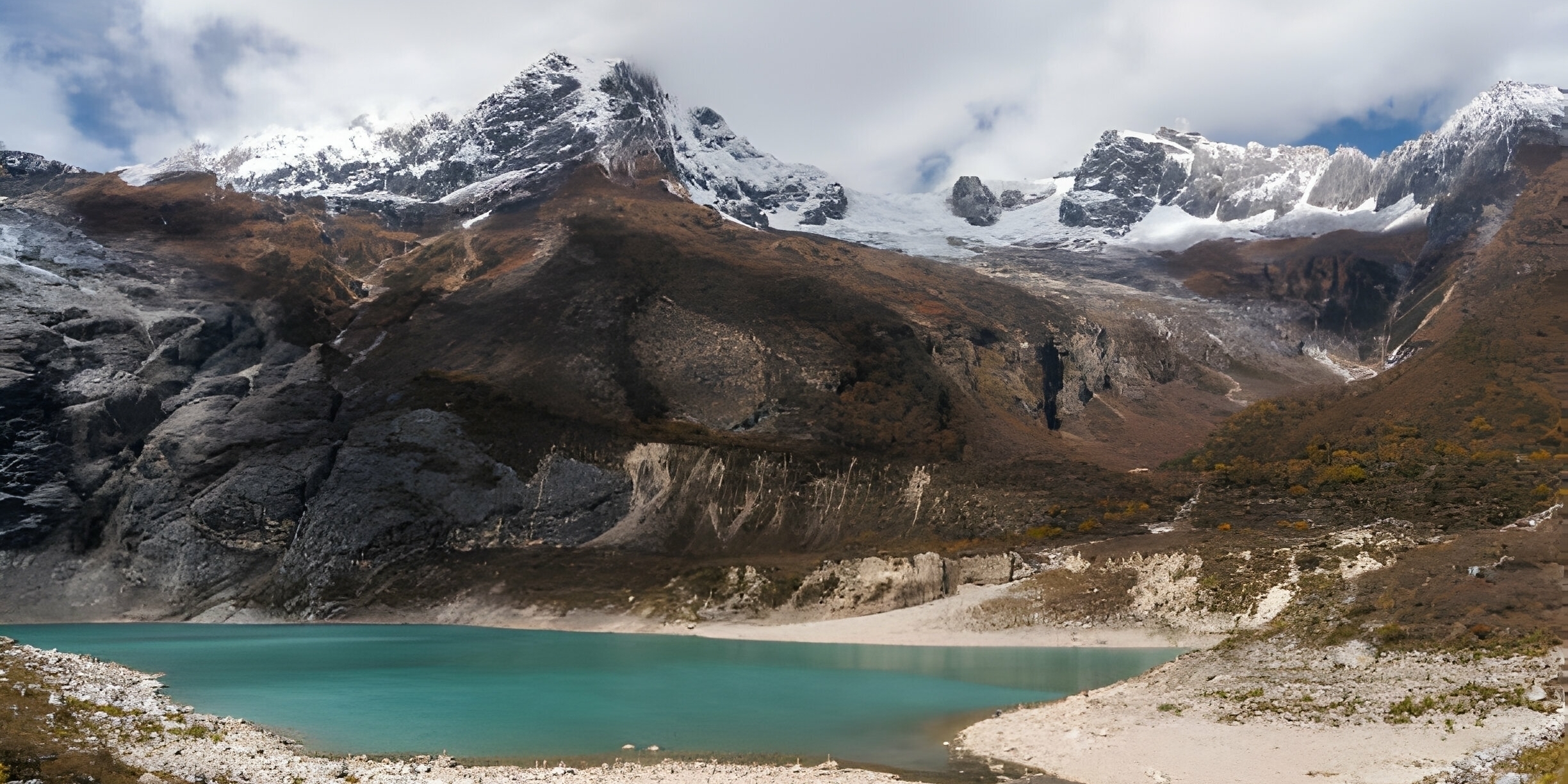
The very next day you will reach Jagat, most aware walking through the jungle in the hope of glancing at beautiful animals and birds, then heading on to the sides of the electric rivers, in continuation to that you will walk by Deng, Namarung, Shya, Samagaon, and Samdo, Before Larky La Pass.
So followed stops forms the Manaslu circuit trek route. Every stop will have a facility of rest or accommodation. At the ultimate point of time, the Manaslu circuit trek route will reach Larkya La Pass, which is the highest point of all. After the mountain passes, the returning journey starts. The Manaslu Circuit trek will start through Bimtang, Dharapani, and Syange. In this way, the completion of the whole circuit will be done.
Day to Day Itinerary
Day 1: Arrive at the Kathmandu Valley
You reach the Kathmandu valley of Nepal. You can check for your accommodation and acclimatize to the new surroundings.
Day 2: Explore the valley
Kathmandu is no doubt of attracting tourists so, you can visit Kathmandu for a day and throughout you can obtain your necessary permits for the trek.
Day 3: To Sotikhola
Your journey starts from the drive to the Sotikhola with the exposure of passing through landscapes.
Day 4: Trek to the Machha khola
Your trek towards the side of the machha khola and along the way you will experience the local culture and landscapes.
Day 5: Trek to Jagat
You will need to continue the trek to Jagat where you stop by and encounter the diverse terrains and charming villages.
Day 6: Trek to Deng
Walk through the dense forest and charming hamlets and you stop to Deng village.
Day 7: Trek to Namrung
You put yourself in a higher altitude as you move higher, heading towards Namrung, and enjoying the mountain views.
Day 8: Trek to Samagaon
A picturesque village Samagaon, will spray their local culture and hospitality to you.
Day 9: Acclimatization in Samagaon
You will rest here and will get a chance for the optional side trips.
Day 10: Trek to Samdo
You will witness here the mountain vistas and the landscapes.
Day 11: Trel to Dharamsala( Larkya phedi)
You will here get prepared for the Larkya La Pass.
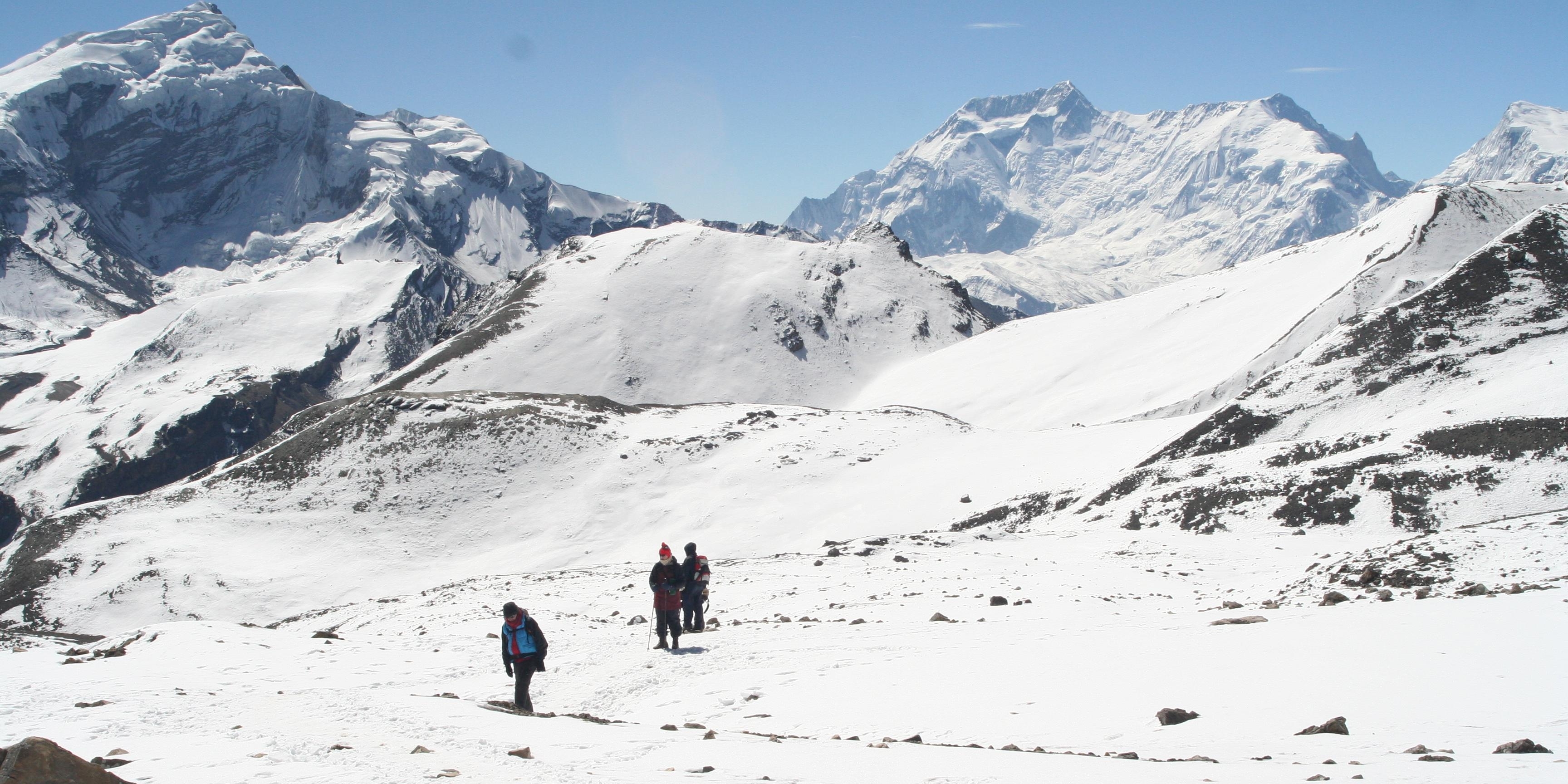
Day 12: Cross Larkya La Pass, Trek to Bimthang
You will reach the highest point throughout the journey and descend back to Bimthang where you will be surrounded by stunning scenery.
Day 13: Trek to Tilije
You continue to Tilije experiencing the varied landscape and local culture.
Day 14: Trek to Tal
You trek through the villages to reach Tal and enjoy the surroundings.
Day 15: Trek to Syange, Drive to Besisahar
You will end your trek at Syange, Besisahar.
Day 16: Return to Kathmandu
Drive back to the valley.
The Manaslu Circuit Trek transcends mere trekking; it evolves into a transformative journey through a realm where majestic peaks, verdant landscapes, and age-old traditions intersect. No wonder other circuits will provide the same but none like the Manaslu Circuit trek does with its challenges and beauty. Allow the map of this extraordinary adventure to lead you through an immersive experience, creating lasting memories in your heart. Strap on your boots, follow the trail, and witness the enchantment of Manaslu unfold, ensuring an adventure that will last a lifetime.
FAQ
1. Where can I find a detailed map of the Manaslu Circuit Trek?
Detailed maps are available at local bookstores in Kathmandu or Pokhara. You can also purchase digital maps from platforms like Google Maps, Gaia GPS, or Maps.me. Trekking agencies often provide maps as part of their package.
2. Is the Manaslu Circuit Trek route well-marked?
The route is generally well-marked, but some remote sections may have fewer signs.It’s recommended to trek with a guide or use a GPS device for navigation.
3. What are the key landmarks on the Manaslu Circuit Trek map?
- Starting Point: Soti Khola or Arughat.
- Major Villages: Machha Khola, Jagat, Deng, Namrung, Samagaon, Samdo.
- Highlights: Larkya La Pass (5,106 meters), Pungyen Gompa, Budhi Gandaki River, and Tsum Valley (if included).
4. Can I use a digital map for the Manaslu Circuit Trek?
Yes, digital maps like Maps.me or Gaia GPS are useful for navigation.
Download offline maps before starting the trek, as internet access is limited in the region.
5. How long is the Manaslu Circuit Trek, and what is the total distance?
The trek is approximately 177 kilometers (110 miles) long from Kathmandu. It typically takes 14-18 days to complete, depending on the itinerary and side trips.
6. Are there any dangerous sections on the Manaslu Circuit Trek map?
The Larkya La Pass and some sections near landslides or river crossings can be challenging.
Always follow your guide’s advice and avoid trekking during monsoon season (June-September).
7. Can I include the Tsum Valley in my Manaslu Circuit Trek map?
Yes, the Tsum Valley can be added as a side trip, extending the trek by 4-5 days. Mark key points from Tsum Valley villages like Chumling, Chhokang Paro, and Mu Gompa on your map.
8. What is the elevation profile of the Manaslu Circuit Trek?
The trek starts at Soti Khola (700 meters) and reaches its highest point at Larkya La Pass (5,106 meters).
The elevation profile includes gradual ascents, steep climbs, and descents.
9. How can I plan my daily itinerary using the Manaslu Circuit Trek map?
Divide the trek into manageable daily stages, considering acclimatization and rest days. Key stops include Jagat (Day 3), Samagaon (Day 7-8), and Dharamsala (Day 10 before crossing Larkya La Pass).
10. Are there any alternative routes on the Manaslu Circuit Trek map?
Yes, some trekkers take alternative routes like the Manaslu and Tsum Valley Combined Trek or the Manaslu and Annapurna Circuit Combined Trek. These routes require additional permits and planning.
11. What should I look for in a good Manaslu Circuit Trek map?
A good map should include:
- Detailed topography and elevation contours.
- Key villages, trails, and landmarks.
- Distances between stops and estimated trekking times.
12. Can I trek the Manaslu Circuit without a map?
It’s not recommended to trek without a map, as the route can be remote and challenging. Always carry a physical or digital map, even if you’re trekking with a guide.
13. Where can I buy a physical map of the Manaslu Circuit Trek?
Physical maps are available in Kathmandu or Pokhara at bookstores like Pilgrims Book House or Himalayan Map House Trekking agencies may also provide maps as part of their services.
14. How accurate are online maps for the Manaslu Circuit Trek?
Online maps like Google Maps or Maps.me are generally accurate but may lack detailed trail information. Use them in combination with a physical map or GPS device for better navigation.
15. What are the key checkpoints to mark on the Manaslu Circuit Trek map?
Key Checkpoints:
Soti Khola (start)
Machha Khola
Jagat
Deng
Namrung
Samagaon (acclimatization stop)
Samdo
Dharamsala (before Larkya La Pass)
Bimthang (after Larkya La Pass)
Dharapani (end).